Geoscience Reference
In-Depth Information
works began in the early seventeenth century, at which point the characteristic rectan-
gular pattern of field boundaries, roads and drains appeared. It is typical of the Peat
Fens that they lack the network of ancient roads and buildings that occur in the Silt
Fens.
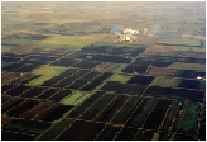
Figure 277 shows a typical view of the southern Peat Fens, with a sugar-beet re-
finery steaming away in the middle distance. The peat soils, open fields and straight
drainage and road boundaries in the foreground contrast with the more ancient field-
boundary pattern behind. The black soils are being lost rapidly, because their drainage
and cultivation are leading to the destruction of the peat.
Before the seventeenth century, the southern Peat Fens were low-lying marshes
with meandering rivers, and the few inhabitants tended to live on local 'islands'. Fen
and marsh people made a living from hunting wildfowl, fishing and harvesting reed,
sedge and willow. Life was not easy because of frequent flooding and the lack of well-
drained land.
FIG
277.
The Peat Fens, looking northwards towards Methwold (Fig. 275,
c3
). (Copyright
London Aerial Photo Library)
FIG
278.
Small Fenland drainage windmill, restored at Wicken Fen in the northeast of
Area 13.
The major drainage work that converted much of the Fens to farmland was
planned and managed by Cornelius Vermuyden (1595-1683). He was born in the Neth-