Geoscience Reference
In-Depth Information
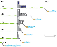
FIG
264.
Destruction of All Saints' Church, Dunwich, over the last 250 years.
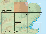
AREA 15: LEICESTER TO THE FENS
In the west of Area 15 (Figs 265 and 266) the scenery consists of low hills and open
valleys in Leicestershire and Nottinghamshire, whereas the eastern scenery is domin-
ated by the spectacular flatness of the Fens. We shall be considering why the scenery
is so different in these two parts of the Area.
The bedrock history of Area 15 is similar to that of the other three Areas of the
East Anglian Region, so the general bedrock succession (Fig. 225) and distribution
map (Fig. 226) provide a perfectly good introduction.
The coastal zone and the inland river system are the active sites of present-day
change to the scenery, so it is useful to start by summarising their map pattern (Fig.
267). The ways these coasts and valleys are related now, and how they have interacted
with the bedrock, will help us to understand the long-term development of the scenery.
The coastal zone of this Area- defined as the ground lying less than 20 m above
sea level - is mostly part of the Fenland Basin (Fig. 268, Landscape
C
), which owes
its exceptional flatness to the thin cover of sediment that has accumulated on the flat
bedrock surface during the last few thousand years of Flandrian sea-level rise. Know-
ledge of this and earlier sea-level changes suggests that some of the present-day slopes
at the edges of the Fens have been carved into the bedrock at times when they formed
the shoreline of the sea or short-lived lakes.
FIG
265.
Location map for Area 15.