Geoscience Reference
In-Depth Information
Rivers must have been eroding valleys during the time between the formation of these
layers, but the evidence of these rivers is largely missing. The surface layer above
the bedrock, however, tells us quite a lot about the conditions in the Ice Age. Deeply
eroded valleys - many of them tens of metres deep - were cut into the Chalk before
being filled with Ice Age sediment. The load-bearing properties of such sediment in-
fills are generally poor, and one of these valleys caused engineering problems during
construction of the Orwell Bridge. Some of the valleys were cut more than 50 m be-
low present-day sea level, confirming that the sea must have been much lower when
the valleys were eroded. Anglian river sands and gravels representing the ancestral
Thames were spread widely over this area, covering the flat plateau picked out in the
aerial photograph (Fig. 256). The Anglian ice-laid material was then deposited, mark-
ing the farthest extent of these ice sheets. In the 400,000 years since this cold spell, the
present valley system of the Gipping and Orwell has been eroded and partly filled with
sediment, most obviously related to the Flandrian rise of sea level since the end of the
Devensian glacial.
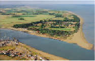
FIG
257.
Felixstowe Ferry crossing over the River Deben, between Felixstowe Ferry, in
the foreground, and Bawdsey Manor, on the far side (Fig. 247,
d3
). The coast continues
to the northeast, where Orford Ness (
d5
) forms the prominent bulge in the far distance.
(Copyright London Aerial Photo Library)
At the mouth of the River Deben (Fig. 257) the passenger ferry crossing is only
about 200 m wide between Felixstowe Ferry and Bawdsey Manor (
d3
), famous as a
key site for radar experimentation during World War II. On the outer coast near the
woods of Bawdsey Manor, outcrops of Early Tertiary London Clay and Late Tertiary
Crag form low cliffs that have been cut since sea level rose following the last glacial.
The estuary of the River Deben extends inland for some 12 km from Felixstowe
Ferry and the sea to Martlesham Creek (the right branch in the photo, Fig. 258) and
the town of Woodbridge (
d4
). The tidal reach of the Deben, up to 1 km wide, is a mar-
vellous example of a river valley with well-developed bends that has been drowned by
the rise of sea level since the Devensian. The 10-20 m shoulders of the valley define
its edges clearly, even though mud has been gathering along the inside of many of the
river's bends, which have sometimes been embanked and drained. At Sutton Hoo, on
the slopes of the Deben Valley opposite Woodbridge, the body of the Anglo-Saxon