Geoscience Reference
In-Depth Information
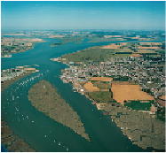
The second kind of coast scenery has formed where the rising sea level has in-
vaded a flat and low-lying land surface, causing the sea to deposit mud on a tide-dom-
inated coast with mud flats and tidal channels. Good examples of this second type
are around Brightlingsea (
c7
) and Mersea Island (
c8
), with the Colne tidal estuary
between. The River Colne estuary extends across the whole of the view shown in Fig-
ure 252, its drowned valley running inland towards Colchester. The mud flats in the
foreground of the photograph show very beautifully the winding patterns formed by
small tidal flood-and-ebb channels on muddy foreshores.
FIG
251.
Slope map of the Stour and neighbouring valleys, also showing the location and
direction of Constable's drawing (Fig. 250).
Landscape D: Suffolk Coast and Heaths (Late Tertiary)
The presence of the Late Tertiary Crag bedrock is used to define the extent of this
Landscape, which is dominated by the coast and the estuaries that have been formed
by the Flandrian flooding of valleys draining the inland parts of Area 14. The Orwell
Bridge (Fig. 253) spans one such drowned valley.
FIG
252.
Looking westwards from Brightlingsea Creek (Fig. 247,
c7
) to Mersea Island
(
c8
) in the distance. Cindery Island is visible in the foreground and, in the bottom right-
hand corner of the picture, the mud flats just east of Brightlingsea can be seen. (Copy-
right Aerofilms)