Geoscience Reference
In-Depth Information
generally low ground with gentle slopes. This reflects the mud content of the lowest
layers of the Chalk succession, which makes them easy to erode compared with the
higher Chalk to the southeast. Views around the Cambridgeshire Fen-edge villages (for
example Burwell,
b1
) and Newmarket (
b3
) provide good examples of this low-lying,
but undulating, Chalk-edge landscape. They lie centrally in a distinctive belt of country
that runs along the north and west edge of the Chalk hills right across East Anglia. The
belt is several kilometres across and runs between the higher Chalk hills to the south-
east, with their surface blanket of Anglian ice-laid material, and the low wetlands of
the Fens to the northwest. Why the Chalk-edge belt lacks ice-laid material is a puzzling
question, but may simply reflect the way river erosion has stripped cover from the edge
of the Chalk hills, leaving the main Chalk landscape still covered with ice-laid mater-
ial. It may also reflect the way this mud-rich bedrock has been particularly prone to
mobilisation under freeze-thaw Ice Age conditions, perhaps even involving thaw-lake
processes (see Chapter 2). The muddy ice-laid material mantling the higher Chalk to
the southeast has made it very difficult to farm, leading to a history of thick tree cover
in contrast to the open character of the Chalk-edge belt to the northwest. Because of
this, the Chalk-edge belt became important in prehistoric times as an area for settle-
ment and a pathway for long-distance travel. The name Icknield Way has been applied
for centuries to the series of ancient roads linking settlements along the Chalk-edge
belt, in recognition of the regional importance of a through-route here.
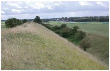
Several Anglo-Saxon boundary markers extend across the Chalk-edge belt, per-
pendicular to its length. The Devil's Dyke (
b2
) near Newmarket is the most completely
preserved of these. On the July Racecourse, the horses race up a gentle but steady in-
cline underlain by the lower part of the Late Cretaceous Chalk and forming the Chalk-
edge hills (Fig. 248).
FIG
248.
The Devil's Dyke in the foreground, with the July Racecourse (Fig. 247,
b2
),
near Newmarket, behind.