Geoscience Reference
In-Depth Information
seems to be a minor river: the present mean flow rate of ≈1.2 m
3
/s from a catchment
of 30 km
2
would not be sufficient to produce a valley of this size. It seems likely that
periglacial processes of slope erosion, as outlined in Chapter 2, also played an import-
ant role in the southeastern migration of the Chalk hills. As an aside, the Ipswichian
gravels from this area have also yielded some remarkable fossils, including the Bar-
rington Hippo now in the Sedgwick Museum, Cambridge.
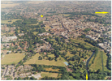
In the foreground of Figure 235, the River Cam (yellow arrow) flows away from
the camera across its floodplain, which can be picked out as a curving belt of college
gardens and parks, swinging to the left and then following the large bend in the river
to the second yellow arrow, where the river leaves the right-hand edge of the view. The
only place where the floodplain has been built over - repeatedly- is the area beside
the earliest bridge over the Cam (now Magdalene Bridge), in the top left of the photo
(starred). This area, where Chalk bedrock has been preserved and the curve in the River
Cam has been constrained, saw development and fortification by the Romans and the
construction of the older colleges and churches of medieval Cambridge. Away from the
present-day floodplain, slopes lead upwards to flat terraces that are fragments of older
floodplains formed as the river carved its valley downwards to its present level.
A recent reversal of the general down-cutting of the River Cam is represented in
Figure 236, a cross-section of the river and its floodplain in the grounds of King's Col-
lege, at the centre of Cambridge. Shallow drillings in this area show that the present
channel is flowing at a higher level than an earlier channel, which appears to have cut
a small valley when sea level was low during the Devensian cold phase (≈20,000 years
ago). This valley was subsequently filled with sediment as the Devensian ice melted
and sea level rose, and the present-day channel has been cut into this sediment infill.
The filling with sediment of a previously incised valley is a common result of the re-
cent Flandrian sea-level rise around Southern England.