Geoscience Reference
In-Depth Information
FIG
233.
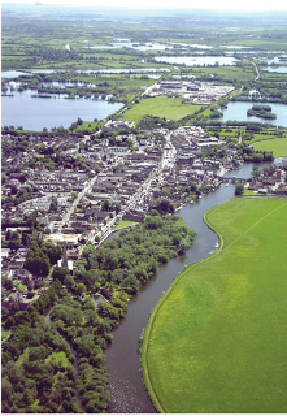
Looking eastwards across the Great Ouse and the town of St Ives (Fig. 231,
b6
; see Fig. 237 for a better idea of the location). (Copyright Cambridge News)
Not far downstream from St Ives, the Great Ouse enters an area that may be
called the Cottenham Flatlands. They appear to have been formed where the River Cam
emerges from the valley that parallels the front of the Chalk hills, and joins the Great
Ouse (Fig. 230). In the surroundings of Cambridge, the alluvial terraces of the Cam
have been studied and their ages have been estimated using their fossil content. The
sketch map (Fig. 234) shows the radial arrangement of the successive pathways of the
river over the last 300,000 years of great climate fluctuation, using a simplified scheme
in which three episodes of river activity are recognised, each with its distinct pathway
and climatic signature.
The fan arrangement reflects the freedom of the river to shift laterally once it
reached the open country downstream from the confining higher ground to the west
and east. The deposits of each of these main phases of Cam activity occur at progress-
ively lower elevations as the river continued to lower the local landscape. Indeed, old
river deposits of sand and gravel appear to have resisted erosion to form high ground
that was then avoided by later floods, diverting younger rivers to new courses.