Geoscience Reference
In-Depth Information
Another feature of the North Downs, clearly seen in Figure 215, is the way that
the northerly slope is covered with distinct valleys running directly down-dip. In some
areas, for example at locality
b1
, just north of Dover, the regularity and parallel trend
of the valleys is remarkable, even though the down-slope dip is only about 1 degree.
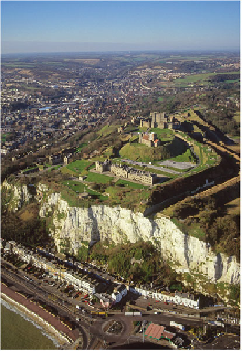
Figure 216 looks northwestwards up the well-defined large valley that cross-cuts the
linear valleys developed on the high Chalk ground that it has traversed. This suggests
that the main valley has been carved very vigorously compared with the linear, paral-
lel, higher valley features, and this may have been caused by pulses of sea-level lower-
ing. The White Cliffs of Dover are also shown in the photograph, but represent a much
younger episode of erosion: the way in which they spectacularly cut across the fortific-
ations of the castle shows just how recently the carving of the cliff has been active.
FIG
216.
The White Cliffs of Dover (Fig. 215,
b2
) with their fortifications, castle and Ro-
man lighthouse. (Copyright Dae Sasitorn & Adrian Warren/www.lastrefuge.co.uk)
Further west in the North Downs, the Chalk valleys are more branched and appear
to have formed by backwards erosion of upper valley ends, which were shaped by mul-
tiple collapse events creating the branches. All the valleys appear to have been carved
and enlarged under Ice Age conditions when the subsurface was permanently frozen,