Geoscience Reference
In-Depth Information
FIG
211.
Natural and man-made features of Area 12.
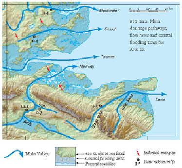
FIG
212.
Main drainage pathways, flow rates and coastal flooding zone for Area 12.
South of the North Downs Chalk hills (see Landscape
B
), there are a number of
hills and valleys that correspond to Early Cretaceous resistant sandstones and weaker
mudstones respectively. Moving southwards corresponds to working downwards in the
rock succession because of the gentle northward slope of the bedrock. The following
features can be observed:
1. A low-lying linear bench that tends to have been eroded in the Early Creta-
ceous Gault Clay, south of the North Downs scarp. Some parts of the M26 and