Geoscience Reference
In-Depth Information
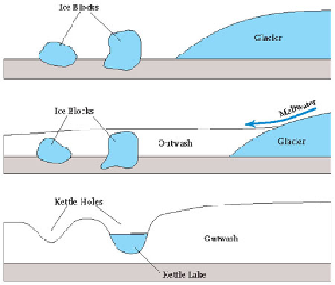
As the climate warmed further and the ice retreated, large blocks of ice buried
within the till melted, causing subsidence and eventually creating a number of small
lakes known as
kettle holes
(Fig. 209). Over the course of the subsequent interglacial,
these small lakes were filled with peat and silt, as well as pollen from the surrounding
vegetation. They therefore provide an excellent record of climatic conditions during
the warm phase, and so are often of considerable interest to climatologists. A number
of kettle holes were discovered during construction work at Hatfield north of London
(
e11
) where they appear as isolated patches of interglacial sediment set within the sur-
rounding glacial till.
Landscape F: The Thames Basin Western Heaths
The Tertiary fill of the London Basin has influenced the landscapes mainly in the areas
surrounding Landscape
C
, with its river floodplains and their terraces. The Bagshot
Beds (Fig. 181) are sandy deposits which overlie the London Clay in parts of the Bas-
in, especially in the southwest, where they define Landscape F. The sand content of
the bedrock here gives rise to nutrient-poor, acidic soils that favour heathland vegeta-
tion and pasture, and are of little use for agriculture. The Bagshot Beds mostly outcrop
around the Reading-Aldershot-Woking area, also known as the Thames Basin Heaths.
The area has been widely taken over for military training purposes, particularly around
the Sandhurst and Aldershot military centres, in the valley of the Blackwater river. The
waters of the Blackwater flow northwards into the River Loddon beside the hills of
Bagshot Heath (
f1
) and enter the Thames to the east of Reading.
FIG
209.
Diagram illustrating the processes of kettle-hole formation.