Geoscience Reference
In-Depth Information
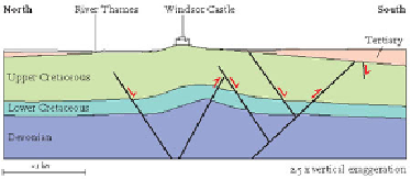
ited by the (royal) family that owns it. This hill owes its existence to the presence of
strong Chalk that was raised up as a small anticline or upfold above faults in the bed-
rock, probably during the Middle Tertiary (Fig. 206). The fold is relatively narrow and
angular, meaning that the Chalk outcrops at the surface over an area only about 1 km
across, creating a prominent, isolated hill and an ideal location for a castle (Fig. 207).
About 470,000 years ago, the Anglian cold episode resulted in ice sheets reaching
their furthest southern position, leaving a distinctive mark on the London area. It was
the only cold episode in the last 2 million years when ice extended as far south as Lon-
don. As the ice advanced, it deposited a glacial
till
of boulders, sand and clay. In places,
this till is closely associated with river-deposited gravels, showing that material was
often transported locally by meltwater streams that ran beneath and in front of the ice.
It is the presence of the till that indicates how far south the ice sheets came.
FIG
206.
The geological structure under Windsor Castle (Fig. 201,
e8
).
FIG
207.
Looking westwards over Windsor Castle (Fig. 201,
e8
) and the River Thames.
(Copyright London Aerial Photo Library)