Geoscience Reference
In-Depth Information
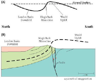
FIG
203.
Sketch sections showing (A) the location of the Hog's Back monocline in the
overall fold pattern and (B) more detailed pattern of folding and faulting around the Hog's
Back.
Landscape E: The Thames Valley and the London hills
In the Early Tertiary, sands and marine muds were deposited over the Chalk in the
centre of the London Basin downfold, forming bedrock deposits such as the London
Clay and Bagshot Beds that underlie much of London. Later crustal compression in
Middle Tertiary times involved further gentle movements of the downfold, along with
steep folding over a few localised faults, which produced structures such as the Hog's
Back.
Landscape erosion then picked out the harder Chalk on the north and south edges
of the basin, creating the Chilterns and North Downs. This created a drainage network
that focused river erosion on the central part of the basin. In time, the ancestors of the
Thames, Colne and Lea developed to form the main stems of today's branching river
pattern (Fig. 200). These rivers have cut progressively downwards into the Tertiary
bedrock, forming floodplains with alluvial sediment at a variety of different levels, of-
ten described as a 'staircase' of river terraces. The staircases provide a record of the
river history of the London Basin over the past million years or so.
The terraces form much of the flat land upon which Greater London is built.
Slough (
e12
), for example, has been constructed upon the ancient Boyn Hill Terrace
and sits above the level of the present-day floodplain. The terraces also contain extens-
ive deposits of sand and gravel that have long been worked and used as a source of
aggregate. The abandoned gravel pits (
e1
) have often filled with water and in time be-
come valuable wetland habitats, recreational parks and water treatment works, such as