Geoscience Reference
In-Depth Information
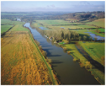
FIG
196.
The River Thames just upstream from Reading and downstream from Pang-
bourne. (Copyright Dae Sasitorn & Adrian Warren/www.lastrefuge.co.uk)
Watership Down, made famous as the title of Richard Adams' 1972 topic, is a
north-facing Chalk edge south of Newbury, on the southerly-sloping (at about 3 de-
grees) fold limb of the Kinsclere Upfold (
c9
). The northern limb of the upfold slopes
more steeply, at about 25 degrees to the north, showing that the general movement
there was down towards the north. This sense of local movement is consistent with
the movement that might be expected on the northern edge of the large London Basin
downfold (Fig. 182).
Landscape D: The Kennet Valley with Early Tertiary bedrock
The final Landscape of Area 10 is defined by its bedrock of Early Tertiary sediments,
marking the western end of the London Basin downfold (Figs 180 and 182). The town
of Reading has grown where the River Thames emerges from its valley incised into the
Chalk to the north and first meets these Tertiary sediments (Fig. 196). The sediments
are largely flat-lying except locally, along the southern margin of the Basin, where they
have been tilted by folding in the Kingsclere upfold (
c9
). The River Kennet is the cent-
ral drainage feature of most of this Landscape, although further west its headwaters
and tributaries (particularly the Lambourn) drain large valleys with numerous dry side
branches in the Chalk Downs.
The Early Tertiary sediments consist of between 100 and 200 m of muddy and
sandy sediment. Some of this was deposited by streams and in swamps, but most of it,
particularly the London Clay, accumulated in what appears to have been an arm of the
sea occupying the London Basin.