Geoscience Reference
In-Depth Information
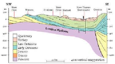
FIG
183.
Bedrock cross-section through the London area, showing the bedrock structure.
As the formation of the London Basin progressed, its northern and southern edges
became elevated, while its central portion was depressed, creating a shallow hollow
some 80 km wide and about 500 m deep. River networks developed and began to erode
the higher ground, transporting sediments inwards towards the centre of the basin. This
erosion quickly picked out the strong layer of Chalk in the bedrock succession and pro-
duced the distinctive Chalk hills that mark the edges of the London Basin today.
Later in the Tertiary, sea level was rising once more, flooding the newly formed
basin as far as Newbury and depositing a thick sequence of marine muds (particularly
the London Clay) over a wide area. The London Clay is one of the best-known and
most extensive Tertiary deposits in England, forming the bedrock beneath most of
Greater London. The properties of the London Clay make it an excellent rock for ex-
cavation and tunnelling, and in 1863 the world's first underground railway was opened.
Today the London Clay beneath London is riddled with tunnels, and the Underground
has become a huge enterprise, used by some 3 million passengers, on average, each
day.
Overlying the London Clay are the pale yellow sands of the Bagshot Formation,
deposited in a shallow marine or estuarine environment as the sea retreated from the
Region once again. The main outcrops are found on Bagshot Heath, an area of elevated
ground around Camberley.