Geoscience Reference
In-Depth Information
The slope pattern of the Cotswold Hills (Fig. 168) reflects directly the distribution
of these Jurassic marker layers. The well-defined Cotswold Edge that extends south-
westerly from Ebrington Hill (
c2
) corresponds to the thickest development of the oolit-
ic limestones, due to environmental conditions or gentle tilting by Earth movements in
Jurassic times. Similarly, the replacement of the prominent Oolite scarp further to the
northeast by a more widespread array of lesser scarps (due to the Marlstone Rock Bed,
Northampton Sand and a thinner Oolite scarp) is an erosional response to changes in
the layer pattern that reflect variations in Jurassic environments and movements (Fig.
173).
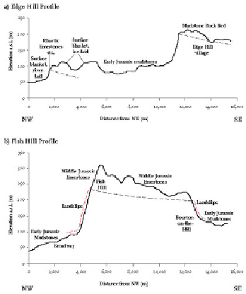
FIG
173.
Comparison of topographic profiles across the northwestern edge of the Cots-
wold Hills, contrasting the northeastern, multi-scarp sector at Edge Hill (a) with the high-
er, single-scarp sector at Fish Hill (b). The sections are located on Figure 168.
(5)
The Portlandian (labelled P on Figs 151 and 168)
The layers above the Oolites are of Late Jurassic age and generally consist of mud-
stones. Most of this younger Jurassic bedrock has not produced distinct topography on
erosion, except in the southeast of the Area, east of Oxford, where limestones of latest
Jurassic age ('Portlandian') cap some well-formed hills.