Geoscience Reference
In-Depth Information
faults that locally run parallel to the directions of the sloping layers in the Carbonifer-
ous strata of the Mendip Hills. In the Bath area itself, the topography is dominated
by the meandering and incised valley of the Avon. Ten kilometres north of Bath, the
main layer capping the Cotswold Hills is the Great Oolite, which is more resistant than
its southerly equivalent, the Forest Marble. The narrow valleys carved with an ESE-
WNW trend into this Cotswold Landscape give it a particularly distinct form in the
area around Marshfield (
f1
).
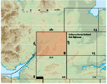
AREA 9: THE COTSWOLDS AND THE MIDDLE SEVERN
The landscapes of Area 9 (Figs 166 and 167) are dominated by the Cotswold Hills,
stretching from the southwest near Gloucester to the northeast near Rugby. They separ-
ate the drainage that flows down the Avon and Severn valleys into the Bristol Channel
from the drainage of the smaller rivers that flow eastwards and southwards, eventually
to the North Sea. Area 9 therefore occupies a central position in the landscape of Eng-
land and Wales, and the fact that it sends stream and river drainage in such different
directions reflects this position.
We shall be considering why the Cotswold Hills exist, why they are located and
oriented the way they are, and why they have such a clearly defined edge south of Eve-
sham. We shall also consider why the River Severn flows southwards down the west-
ern edge of the Area, and why the large cities of Birmingham and Coventry have de-
veloped along the northern edge of the Area. On their eastern and southern flanks, the
Cotswold Hills generally lack a well-defined margin, although important cross-cutting
valleys there have provided routes for the roads, railways and canals that run between
London and the Welsh Borders.
FIG
166.
Location map for Area 9.