Geoscience Reference
In-Depth Information
Review of the landscape history
The oldest features of the scenery of Area 7 must be the major river valleys of the
Rother, Tillingham and Brede, which started to erode downwards into the rising land
surface when the Weald uplift began some 30 million years ago. These rivers have ex-
cavated the intricate valley patterns of the High Weald, the low and subtle drainage
patterns of the Low Weald, and the more marked scarps and valleys of the Wealden
Greensands and Chalk.
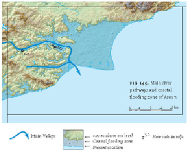
The second group of landscape features are those that reflect changes in sea level.
There is no clear dating evidence for high-stands of the sea earlier within the Tertiary,
but the evidence for Holocene flooding by postglacial sea-level rise is abundant and has
been discussed above. So also has the possibility that the Romney Marshes degraded
cliff line may date from the high sea level associated with the Ipswichian interglacial,
some 125,000 years ago. The evidence for this is based not on direct dating, but on the
configuration of the land as represented by the 'coastal flood zone' shown in Figure
149. This figure highlights the inland valley patterns, and also identifies the large pro-
portion of the Area sensitive to fairly small changes in sea level.
FIG
149.
Main river pathways and coastal flooding zone of Area 7.