Geoscience Reference
In-Depth Information
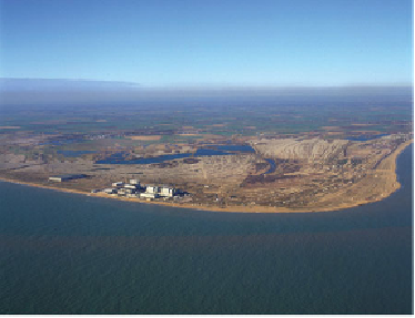
FIG
146.
Photograph looking northwestwards over Dungeness and the nuclear power
stations (Fig. 140,
e1
). The lines or ridges on the surface of the promontory mark the po-
sitions of former coastlines. (Copyright Dae Sasitorn & Adrian Warren/
www.lastrefuge.co.uk)
The surface of the main Dungeness promontory is only lightly vegetated, and very
clearly shows large numbers of distinct lines or ridges, locally called 'fulls' and vis-
ible in Figure 146. Groups of these ridges trend in different directions, and excavations
made during the construction of the power station show that they mark the tops of sed-
imentary layers, sloping downwards towards the sea at about 9 degrees. These layers
were formed during storms when gravel was deposited on the sloping surfaces of old
beaches. This means that the pattern of lines provides a record of the positions of act-
ive beaches over time, making it possible to plot the way the promontory has grown
and changed in the past (Fig. 147). Where the lines have been truncated by the present
coast, an earlier episode of deposition by storms must have been followed by a later
episode of net removal, causing the movement of the coast landward.
As Figure 147 shows, analysis of these lines provides evidence for an early epis-
ode of build-out of the coastline in the southwest of this Landscape, near Rye. The
building of the large promontory of present-day Dungeness, further to the east, has oc-
curred more recently, and has been accompanied by large amounts of erosion south of
Rye (Fig. 148), as well as some lesser erosion to the northeast, about 5 km southwest
of Hythe, where a wall has been constructed to protect the coastline.