Geoscience Reference
In-Depth Information
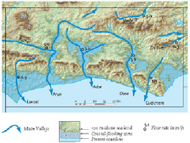
FIG
136.
Main river pathways and coastal flooding zone of Area 6.
AREA 7: EAST SUSSEX AND SOUTHEAST KENT
More than half of this Area rectangle is occupied by the sea (Figs 137 and 138). The
coastline extends from Bexhill in the west, where the sea is eroding cliffs in the Early
Cretaceous High Weald bedrock, to Folkestone in the northeast, where the cliffs have
been formed by erosion of the Early Cretaceous Lower Greensand and Gault and the
Late Cretaceous Chalk. Between these two sections of coastal cliffs is a large area of
young surface blanket forming Dungeness and Romney Marsh.
FIG
137.
Location map for Area 7.