Geoscience Reference
In-Depth Information
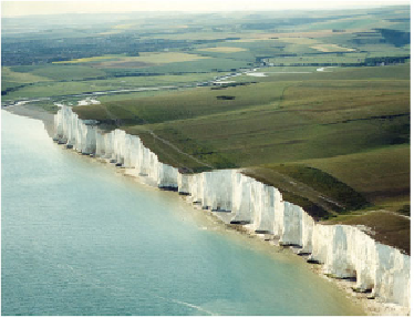
FIG
133.
Looking northwestwards over the western Seven Sisters and the Cuckmere val-
ley. (Copyright Aerofilms)
Many scientists have considered the way that the river and stream drainage pattern
of the Weald may have developed. A focus of this interest has been the way that a
rather regular series of large valleys cuts right through the South Downs, carrying wa-
ter southwards from Landscapes
A, B
and
C
(Fig. 136). From west to east, the Arun,
Adur, Ouse and Cuckmere pass through clear valleys sometimes called water gaps, and
it has been concluded that they are the descendants of rivers that originated early in the
history of the Weald uplift as the bedrock layers became tilted. On the high ridge of
the South Downs, between these cross-cutting
water gaps
, a similar number of
wind
gaps
or low points have been identified. It has been suggested that they may represent
early valleys that were abandoned by their rivers as the drainage pattern evolved and
tributaries cut back to deflect or capture other streams.
Landscape E: The South Coastal Plain
This remarkable coastal-plain Landscape stretches all the way from Southampton
Water and Portsmouth in the west (see Area 5) eastwards, via Selsey Bill (Fig. 134),
as far as Brighton (Fig. 135). It provides clear evidence of the way that coastal pro-
cesses, coupled with sea-level changes, have created a zone where bedrock structures
have been planed down by storm-wave action and covered by a thin veneer of gravel
and wind-blown
brickearth
(a fine-grained sand).
The bedrock structure here involves the folding of the Chalk and Early Tertiary
sediments (the London Clay and Bracklesham Beds; Fig. 128) into the distinctive
Chichester downfold
(
e1
), the
Portsdown upfold
(
e2
) and the
Littlehampton upfold
(
e3
).