Geoscience Reference
In-Depth Information
as 'hammerponds'), and these in turn powered bellows for the smelting of the iron
and forge hammers for working it. The forges were fuelled using charcoal from val-
ley and slope woodlands, and the industry eventually died because the northern British
coalfields became recognised as a more efficient source of heat and power.
FIG
130.
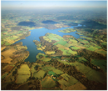
Typical High Weald landscape, looking eastwards over Bewl Lake (Fig. 129,
a1
). Copyright Dae Sasitorn & Adrian Warren/www.lastrefuge.co.uk)
Landscape B: The Low Weald
In Area 6, the Low Weald extends in a belt to the south and west of the High Weald,
from Haslemere in the west, past Horsham and Haywards Heath, and on towards
the sea between Eastbourne and Hailsham, where it passes into the Pevensey Levels
(Landscape
F
).
This rather flat and featureless Landscape owes its lack of topography to the uni-
formity of its bedrock, which is the upper division of the Wealden beds known as the
Weald Clay (Fig. 128). There is an obvious contrast in elevation and the presence of
slopes between this Weald Clay landscape and the higher and more hilly topography
seen in Landscapes
A
and
C
. In a few locations, the Weald Clay does contain thin sand-
stones and freshwater limestones which create some topography, but they are much
less common here than in the Greensand below and the Hastings Beds above.
The Vale of Fernhurst (
b1
) at the western edge of Area 6 has a floor of Weald Clay
sandwiched between scarps cut in the Lower Greensand. In some places, these scarps
are due to the presence of an important, erosion-resistant sandstone (the Hythe Beds)
in the lower part of the Lower Greensand. In other places, distinct slopes seem to have
been carved in the Wealden below the actual Lower Greensand boundary.