Geoscience Reference
In-Depth Information
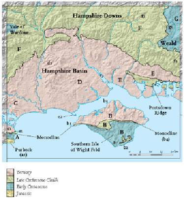
FIG
116.
Geology and hillshade map of Area 5, showing Landscapes
A
to
G
and localit-
ies (
a1, a2
etc.) mentioned in the text.
Landscape A: The Isle of Purbeck
A description of the westward continuation of this Landscape is given in Area 4. Here
it is enough to note that, as in Area 4, the Isle of Purbeck is defined by two distinct-
ive ridges. The northernmost of these is the Chalk ridge north of Swanage, which has
been formed by the erosion of the stepfold that also runs through the Isle of Wight
(Fig. 117). Figure 118 shows the cliffs around Old Harry (
a1
), where the near-hori-
zontal Chalk has been eroded by storm waves to create numerous small bays. The re-
markable feature of this erosion is the way that the waves swing round to attack both
sides of the main headland, resulting in well-defined, almost parallel-sided 'bites' in
the cliff line. The southernmost distinctive ridge is formed by the Late Jurassic/Early
Cretaceous Portland and Purbeck limestones, which form a high plateau (
a2
) south of
Swanage. Jurassic Kimmeridge Clay forms the base of the cliffs along the south coast
of Purbeck, and its preferential erosion by storms has undermined the cliffs in many
places, causing frequent land-slipping (Fig. 119). Swanage itself lies in the low ground
of the Corfe Valley, on soft Wealden mudrock.