Geoscience Reference
In-Depth Information
Landscape C: The Blackdown Hills and Sidmouth to Lyme Bay
This Landscape consists of flat-topped hills dissected by numerous valleys, extending
from the Blackdown Hills (
c7
) on the Devon-Somerset border to Sidmouth and Lyme
Regis (
c6
) on the Jurassic Coast.
The extensive flat caps of these hills are made of a resistant sheet of Early Creta-
ceous Gault (marine silts and clays) and Upper Greensand (marine sands and silica-
rich, flint-like cherts), and the geological map shows that every ridge is underlain by
a finger of this bedrock. In the general introduction to this chapter I described the
Western Unconformity that forms the western edge of the Southeast England Basin
(Fig. 94). The resistant cover of Early Cretaceous sediments forms the upper cap of
this unconformity.
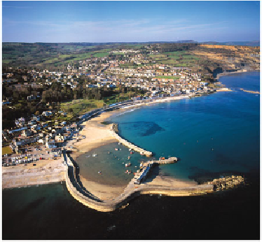
FIG
103.
Looking northeastwards over Lyme Regis, with Golden Cap in the right back-
ground (Fig. 99,
c6
). (Copyright Dae Sasitorn & Adrian Warren/www.lastrefuge.co.uk)
Locally, the Early Cretaceous layer is covered by patches of Late Cretaceous
Chalk, and there is also often a widespread soil cover known as
Clay-with-flints.
This is
interpreted as an ancient (possibly early Tertiary) weathering product, involving solu-
tion of the underlying Chalk bedrock to yield a concentrate of less soluble flint and
chert materials.
The surface of the Western Unconformity is visible in this Landscape over an area
approximately 30 km by 30 km, and it slopes very gently to the southeast, from an
elevation of 230 m inland to just 70 m around Lyme Regis (Fig. 103). As the uncon-
formity was originally formed by erosion at sea level about 100 million years ago, it