Geoscience Reference
In-Depth Information
varying intensity are felt throughout the region over the course of the next few days.
Soil liquefaction is extensive throughout the area.
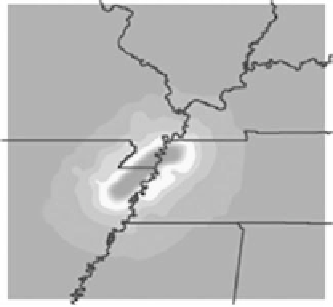
Figure 1 Scenario Fault Location
Area of Impact
The significantly damaged area extends from the southwestern portion of
Kentucky, the southeastern section of Missouri, and the northeastern portion of
Arkansas. The heaviest impact to Kentucky encompasses 14 counties including
the following:
1 Ballard
6 Daviess
11 Hopkins
2 Caldwell
7 Fulton
12 Livingston
3 Calloway
8 Graves
13 Lyon
4 Carlisle
9 Henderson
14 McCracken
5 Crittenden
10 Hickman
IL
IN
MO
KY
TN
AK
LA
MS
Figure 10.5
Scenario fault location.
Direct Earthquake Damage
Initial reports for Kentucky indicate more than 300 fatalities; 1200 injuries, with
1000 of these people requiring hospitalization. Thousands are missing or separated
from their families. The preliminary estimate of displaced persons is 20,500 but
this number is expected to increase within the first three days. Thousands of homes
and possessions are destroyed or damaged. There are major shortages of essential
supplies, such as fresh food, bottled water, fuel, and generators.
Collapsed bridges and roadways and sunken shipping vessels cause oil and haz-
ardous material (HazMat) contamination along the Mississippi River. The river