Geoscience Reference
In-Depth Information
qualitative methods can be usefully applied during map-
ping. Some interpreters annotate their maps with dip and
plunge symbols equivalent to the plotting of these when
geological mapping. How source orientation is estimated
depends on the nature of the geophysical response, and it is
more easily achieved with some kinds of geophysical data
than others. We describe this kind of interpretation in our
descriptions of the individual geophysical methods and
restrict ourselves to some general statements here.
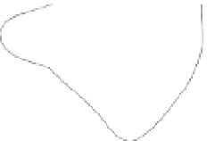
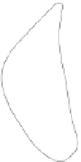
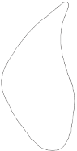
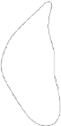
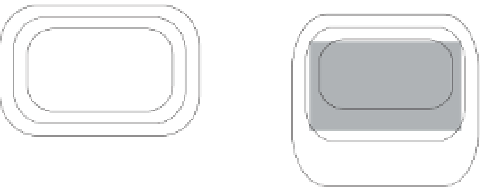
The key property is anomaly asymmetry which is mani-
fest as the variation in gradients at the margins of a
geophysical anomaly (
Fig. 2.43
). The shallower (low)
Amplitude
Amplitude
Amplitude
Dip
Plunge
A
A'
A
A'
A
A'
Location
Location
Location
a)
A
A
Dip
A
A'
Plunge
A'
Contours
A'
b)
c)
20
0
0
100
Metres
Metres
4
4
0
8
12
1
10
2
600
50
100
16
500
200
300
24
28
400
Massive sulphides
Disseminated sulphides
Figure 2.43
Assessing dip and plunge from contour spacing. (a) Schematic illustration of variations in gradients associated with dipping and
plunging sources. The increase in contour spacing is the dip/plunge direction. (b) Applied potential data (mV/A) from the Telkkälä Taipalsaari
nickel sulphide deposit in southeastern Finland. Redrawn, with permission, from Ketola (
1972
). (c) Gravity response (gu) of the Pyhäsalmi


Search WWH ::

Custom Search