Geoscience Reference
In-Depth Information
the radiometric survey to be resolved by the survey. Levin-
of disequilibrium for uranium exploration. There is no
simple way to identify areas of disequilibrium. Geological
settings where it is most likely to occur include areas where
groundwater is discharged; reducing environments such as
swamps; and situations where porosity is increased, say by
physical weathering, to encourage loss of Rn gas.
with increases in terrain clearance causing a decrease in the
amplitude of the radiometric response and vice versa.
Methods have been developed for upward- and
downward-continuation of radiometric data, i.e. to calcu-
late how the data would appear for a different source
-
detector separation, which partly address topographic
effects. However, their routine application is not current
practice, probably because of the relatively high noise levels
of survey data. Recognising topography-induced artefacts
is one of the main reasons that topographic data are
required in the interpretation of radiometric data.
4.7.2.2
Topographic effects
The reduction of radiometric survey data described previ-
ously (see
Section 4.4
)
assumes that the source of the
radiation is a flat horizontal surface located below the
sensor. The approximately exponential decrease in radi-
ation intensity with increasing height, owing to attenuation
(see
Section 4.4.6
), means that radiometric measurements
are particularly sensitive to source geometry.
Ground radiometric measurements are particularly
prone to the effects of terrain forms in the immediate
vicinity of the measurement. Relief in the terrain causes
variations in the distance between the sensor and the
4.7.3
Responses of mineralised environments
For many types of deposit, the mineralisation itself,
associated alteration zones and lithotypes favourable for
mineralisation may all have anomalous radioelement com-
positions, either in a particular radioelement or a particular
ratio of elements. Because of their large size, alteration
zones are the most likely candidates for direct detection
by radiometric surveys.
Radiometric responses associated with mineralised
environments vary from very clear to very subtle. In the
latter case, they may be disguised by apparently similar
responses of, for example, weathering or changes in over-
burden type and thickness. Even highly radioactive deposits
can be completely concealed by thin cover, but even when
the mineralisation does not outcrop there is sometimes
anomalously radioactive material at the surface which can
be detected. This may be bedrock material brought to the
surface and transported and exposed by erosive processes,
or may be due to a U-halo produced by the mobilisation of
uranium by gaseous diffusion or transportation in ground-
water. The anomalous zone may extend over a larger area
than the deposit itself, drawing attention to the area.
It is worth investigating all ratios and combinations of
K, eU, eTh and TC in an attempt to identify anomalies and
anomalous signatures. In all cases, ternary images of the
radioelements and composite elemental ternary images
(see
Section 4.5.3
)
are effective for targeting anomalous
areas for further analysis using individual channel ratios.
A description of the radiometric responses from some
common types of mineral deposit, and techniques for
detecting and mapping them, follows.
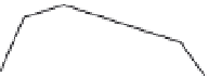
-ray
measurements are made in a gully or valley, the sources of
radiation in the rock walls are closer to the detector,
causing the readings to be higher than if they were made
on
flat ground. A measurement made adjacent to a cliff or
mine bench will be about 50% higher than a measurement
made on flat ground formed of the same material. Con-
versely, when measurements are made on a ridge the
laterally offset sources of radiation are more distant from
the detector, causing a lower reading.
As with other airborne geophysical measurements, it is
important for the aircraft to maintain constant terrain
clearance in order to minimise false radiometric responses.
As described in
Section 2.6.3.2
, this is not always possible,
γ
Sensor
Reading higher than
on flat terrain
Reading lower than
on flat terrain
4.7.3.1
Mineralisation
Radiometric surveys have led to the discovery of many
deposits of uranium of disparate types. Some examples
Figure 4.22
Schematic illustration of the radiation source areas of
various terrain forms for ground radiometric measurements.


Search WWH ::

Custom Search