Geoscience Reference
In-Depth Information
3.9.8
Magnetic property measurements and
their analysis
intersected by several large northeast-trending faults.
A sinistral displacement of about 2 km on the Custer
Fault post-dates the mineralisation, which occurs in two
distinct districts a few kilometres apart. The southern
area, from where most of the data were collected, occurs
around the General Custer Mine and has produced sev-
eral million ounces of Ag from a vein-system within
andesitic lavas. Wall-rock alteration is pronounced and
includes silicification, sericitisation and chloritisation.
The system is thought to occur above a quartz monzo-
nite intrusion, whose roof zone is exposed in places,
which would have been the source of hydrothermal
fluids. The second area, which contains the Sunbeam
Mine, contains both Ag and Au but production is
much less than the southern area. Mineralisation is
spatially associated with rhyolitic intrusions and associ-
ated with argillic alteration surrounded by wide zones
of propylitisation.
Density, magnetic susceptibility and strength of rem-
anent magnetism, and the variation on oxygen isotope
ratio (
Magnetic susceptibility is relatively easy to measure in the
field on rock samples and on actual outcrops. Remanent
magnetism on the other hand is far more difficult to
measure. It requires specialist laboratory equipment, and
samples must be geographically oriented in order to
resolve the direction of the remanent field. An unfortunate
consequence of this is that usually more susceptibility data
than remanence data are available, so the actual magnetic
properties of the various rock formations are only partially
de
ned.
3.9.8.1
Measuring magnetic susceptibility of samples
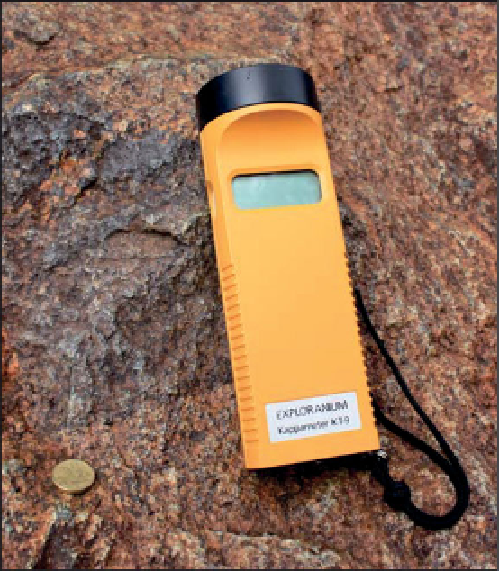
A range of hand-held susceptibility instruments for use in
They are lightweight, robust and easy to use: this involves
placing the instrument next to the rock sample, or outcrop
face, and pressing a button to display the measurement.
Some models store the data for subsequent downloading.
The measurement is influenced chiefly by material within
about 20 to 30 mm of the surface, so the shape and size of
the specimen influence the reading obtained. Usually the
specimen needs to be at least the size of one
18
O) data were collected at 78 locations mainly in
and around the southern mineralised district. The oxygen
isotope data show two zones of very low values inter-
preted to be due to the effects of meteoric
δ
hydrothermal
fluids. These coincide with the two mineralised districts,
allowing for the later offset on the Custer Fault which
cuts the southern district, and probably de
ne the extent
of intense hydrothermal activity. The susceptibilities and
strengths of remanent magnetism of intermediate lavas
within the low
-
s st and
have a flat surface for the measurement, and be free of
magnetic materials such as steel core-trays. An instrument
'
18
O zones, indicative of hydrothermal
alteration, are distinctly lower than the surrounding
areas. The rocks with lower magnetism have undergone
intense argillisation with their primary magnetite des-
troyed by oxidation and hydration. In a few cases, hydro-
thermal magnetite occurs in highly altered rocks,
increasing their magnetisation. The isotopically inferred
hydrothermal zone closely correlates with the regions of
reduced magnetism. The reduction in magnetic proper-
ties is suf
cient to be detected by aeromagnetic measure-
ments. An excellent example of modern aeromagnetic
data mapping alteration zones associated with epithermal
Au
δ
Ag mineralisation at Waihi-Waitekauri, New Zealand,
is described in
Section 4.7.3.2
.
Examples of anomalous magnetism of host lithotypes
include large intrusions hosting magmatic deposits,
kimberlites and Au
-
Bi mineralised ironstones in the
Tennant Creek Inlier, Northern Territory, Australia (Hos-
-
Cu
-
Figure 3.58
An Exploranium KT-9 portable hand-held magnetic
susceptibility meter for
field use.

Search WWH ::

Custom Search