Geoscience Reference
In-Depth Information
aircraft are known as aeromagnetics, and those made from
a helicopter as helimagnetics. Magnetic gradiometer
measurements are also common and have the same advan-
tages and disadvantages as their gravity counter parts, i.e.
improved spatial resolution but inferior detection of deeper
sources. Tensor measurements (see
Section 2.2.3
)
are
sometimes made but are not yet common.
The magnetic
field varies less with elevation than the
gravity field, so it is not necessary to collect accurate height
information during a survey. Also, TMI measurements do
not require the sensor orientation to be monitored. Conse-
quently, the process of measuring the magnetic field is
logistically
a)
GNP NP
simpler
than the
gravity measurements
described in
Section 3.3
.
Here we describe the characteristics of the Earth
Geomagnetic
field lines
SP
GSP
'
s mag-
netic
field, and the instruments and survey procedures
used for measuring it on the ground and in the air.
Downhole magnetic surveys are undertaken to explore
around a drillhole and to assist with target delineation,
detailed descriptions of using a downhole magnetometer to
investigate Au-Cu-Bi mineralised ironstones at Tennant
Creek, Northern Territory, Australia; and Hattula (
1986
)
describes downhole magnetometer surveys in the
Otanmäki vanadium mineralised ironstone and the Kota-
lahti Ni
b)
Magnetic
north
Geographic
north
Horizontal
component of
F
Declination
(Dec)
Inclination (Inc)
Geographic
east
Vertical
component
of
F
(VMI)
-
Cu sulphide vein system in Finland.
3.5.1
The geomagnetic field
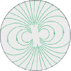
Approximately 90% of the Earth
s magnetic field can be
represented in terms of the field of a very large hypothetical
bar-magnet located within the Earth (
Fig. 3.20a
)
. It is a
good representation of the field resulting from, most likely,
a complex system of electric currents flowing in the Earth
'
Down
Figure 3.20
(a) Approximation of the geomagnetic field by a
dipole inclined to the Earth
'
s axis of rotation. The actual magnetic
poles do not coincide with the dipole
'
s geomagnetic pole or the
geographic poles. GNP
-
geomagnetic north pole, GSP
-
geomagnetic south pole, ME
-
magnetic equator, NP
-
north
geographic pole, and SP
-
south geographic pole. VMI
-
vertical
magnetic intensity. (b) Elements defining the geomagnetic field
(F). The
s
core and driven by convection-related processes. The north
pole of a magnetic compass needle, which is a small bar-
magnet, seeks the south magnetic pole of the Earth
'
field
(because unlike poles attract). This is actually located in the
vicinity of the north geographic pole, and vice versa.
Following the convention described in
Section 3.2.3.1
,
the
geomagnetic
field at the surface of the Earth is then
directed towards the North. The long axis of the hypothet-
ical bar-magnet is oriented approximately 10° from the
Earth
'
s
field direction is de
ned by the angles of inclination (Inc)
and declination (Dec).
rock magnetism in the upper crust cause short-wavelength
spatial variations in the
field, which are superimposed on
the long-wavelength variations originating within the core.
Mapping the spatial changes in the magnetic field due to
crustal features is the principal objective of magnetic
surveying.
s axis of rotation, so the geomagnetic and geographic
poles are not coincident.
The relatively stable main
field originating from the core
is known as the internal field. It is responsible for the
induced and remanent magnetism of rocks. Changes in
'


Search WWH ::

Custom Search