Geoscience Reference
In-Depth Information
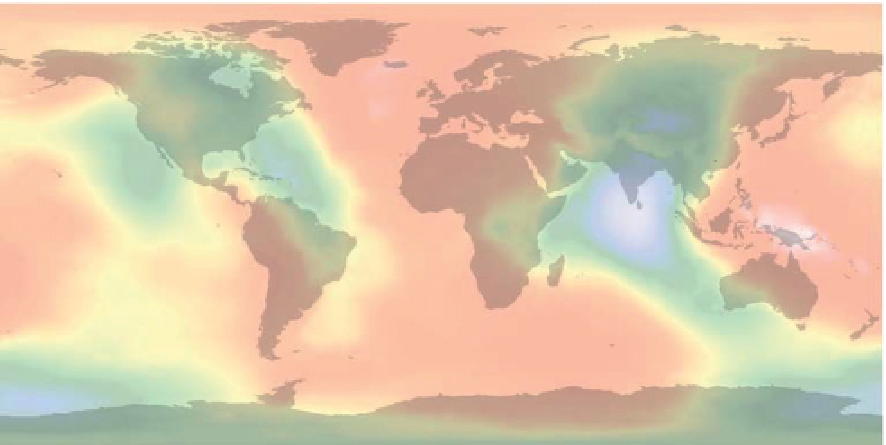
a)
Vertical - the direction along which gravity is measured
Topographic surface
Reference spheroid
Negative separation
Geoid
Positive separation
b)
180°W
120°W
60°W
0°
60°E
120°E
180°E
90°N
0
0
60°N
30°N
0°
-90
30
30°S
30
60°S
-30
90°S
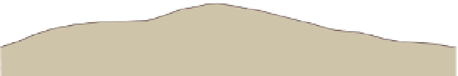
Figure 3.15
(a) Relationship between the undulating geoid and the smooth reference spheroid. Vertical is everywhere perpendicular to
the geoid. (b) Separation between the WGS84 spheroid and the EGM96 geoid. Computed using data from Lemoine et al.(
1998
).
Units are metres.
represents the change in gravity with north
-
south distance
3.4.5
Variations in gravity due to height
and topography
from a base station and is given by:
g
ϕð
N
S
Þ
¼
0
:
00812 sin 2
ϕ
gu
=
m
ð
N
S
Þ
ð
3
:
14
Þ
Topography influences gravity measurements because it
causes variations in station elevation, i.e. the distance
between the station and the centre of the Earth
where
is the latitude (negative for southern hemisphere)
of the base station. This formula is accurate enough for
most exploration applications for distances up to about
20 km north and south of the base station (preferably
located central to the survey area). It is useful where the
latitudes of the gravity stations are unknown. The latitude
correction at a gravity station is simply the north
ϕ
s mass, cf.
forming the mass of the topography. They exert their own
gravitational attraction which tends to oppose the decrease
in gravity caused by increasing elevation, but as predicted
by
Eq. (3.3)
, the attraction of the mass has less effect than
the distance factor. Terrain effects can be as complicated as
the terrain itself; they are particularly strong in gravity
gradient measurements.
Compensation of height and topographic effects
involves three sequential corrections, known as the free-
air, Bouguer and terrain corrections. When the gravity
meter is located on the surface of the topography, the usual
situation for a ground survey, all three corrections are then
based on the height of the topography above some datum
'
-
south
latitude gradient multiplied by the north
south distance
(in metres) between the station and the base station.
Since gravity increases towards the poles (
Fig. 3.14b
), the
correction is subtracted for stations located on the pole
side of the base station and added for stations on the
equatorial side.
Station location needs to be known to about 10 m
north
-
south in order to calculate the latitude correction
to an accuracy of 0.1 gu.
-


Search WWH ::

Custom Search