Geoscience Reference
In-Depth Information
Table 6.1
Magnitude distribution of mainshocks in Gujarat from
1684 to 2012
M Year
2-2.9
3-3.9
4-4.9
5-5.9
6-6.9
7Rem.
1668-2000
11
79
62
27
2
1
183
2001-2012
17
26
14
6
—
1
63
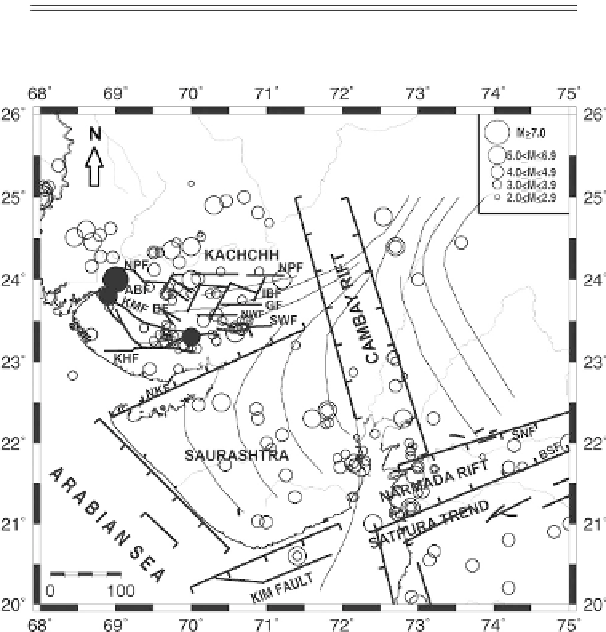
Figure 6.9 Significant faults and epicenters of earthquakes of magnitude
2 from 1684 to 2000
excluding aftershocks in Gujarat. Filled circles are the three significant events in Kachchh of 1819,
1845, and 1956. The Proterozoic-age Aravali trend branches off in three directions. In Kachchh it
becomes E-W, along which faults might have formed.
experienced the severely damaging 1970 Bharuch earthquake of M
w
5.4 at its western end
and larger earthquakes further east, including 1927 M
w
6.3 Son, 1938 M
w
6.5 Satpura,
and 1997 M
w
5.8 Jabalpur. The third seismic zone consists of the Cambay basin, east
and southeast of Kachchh, and the Saurashtra Peninsula, south of Kachchh, which has
experienced seismicity of magnitude less than 6.
Seismic networks have been operating since 1976 and earthquakes of magnitude
3.5
are routinely located. Most of Gujarat having been heavily populated for centuries, it is
expected that for the past 200 years no earthquake of magnitude
4 has been missed, as
such earthquakes are felt strongly over wide areas. Their locations may have an accuracy of