Geoscience Reference
In-Depth Information
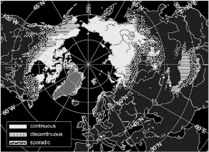
Figure 2.15.
Northern Hemisphere permafrost distribution, simplified from the
International Permafrost Association map. Black areas indicate continuous permafrost,
striped areas indicate discontinuous permafrost, and stippled areas indicate sporadic
permafrost (courtesy of C. Oelke, NSIDC, Boulder, CO).
geothermal heat fluxes and high bedrock conductivity. There is extensive discontin-
uous permafrost southward from the zone of continuous permafrost in Siberia and
Canada, and also in northern Scandinavia. The typical thickness is approximately
50 m in the discontinuous zone, but only a few meters where the distribution is spo-
radic. Exposed treeless ridges and north-facing slopes are underlain by permafrost,
whereas it may be absent in forested valleys, especially where there are large lakes.
In general, the permafrost thins southward and becomes sporadic. Eventually it is
found only in islands in favorable locations. Some of these permafrost islands may
be relics that are unstable under the present climate.
North of the Arctic coastline, there is a considerable zone of submarine perma-
frost underlying shallow sections of the continental shelf seas. This zone is exten-
sive in the Barents, Kara, Laptev, and East Siberian seas, but is narrower in the
Chukchi and Beaufort seas. These shelf areas were exposed during the glacial inter-
vals of the Pleistocene (
Chapter 10
) when global sea level was lowered by 120-135
meters, and the mean winter air temperatures fell well below modern values. The
modern occurrence and characteristics of submarine permafrost are determined by
a number of factors. These include the water mass structure and vertical circulation,
the absorption of solar radiation in summer when the coastal seas are ice-free, and
the corresponding heat loss to the atmosphere in winter through polynyas and leads,