Geoscience Reference
In-Depth Information
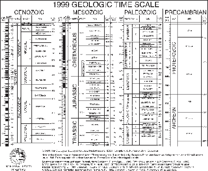
Figure 10.1.
The geologic time scale (from the Geological Society of America, product
code CTS004, compiled by A.R. Palmer and J. Geissman, by permission of Geological
Society of America).
plates in different directions. We now believe that the supercontinent Pangea broke
up roughly 200 Ma during the early Jurassic period. Continental drift is of course
still occurring, but by about 2 Ma the continents looked largely as they do today.
Just prior to the breakup of Pangea, the present Arctic land masses were located
in mid-latitudes. Displacement of the region to north of the Arctic Circle occurred
around 100 Ma during the Cretaceous. The Canadian Basin and Makarov Basin
seem to have originated during the Cretaceous period. Sea floor spreading increased
in the early Tertiary (about 57 Ma) when Greenland separated from Eurasia and
the Eurasian and Nordic basins formed (Vogt,
1986
). This changing distribution of
lands and ocean and mountain-building events (orogenies) had strong impacts on
climate. In the Paleocene and Eocene epochs (60-50 Ma), Ellesmere Island seems
to have supported many subtropical vertebrate fauna in a swamp-forest environ-
ment (McKenna,
1980
). Deciduous conifer species grew in west Greenland and
Spitsbergen. A deepwater connection to the Nordic Seas via the Fram Strait devel-
oped around 35 Ma. This was about the time when temperatures of the global ocean
surface and bottom waters began to decrease sharply. Global sea level lowering in
the late Miocene (6.5-5.2 Ma) led to isolation of the Arctic Ocean and exposure of
the shelf areas (Danilov,
1989
). However, a major marine transgression (sea level