Geoscience Reference
In-Depth Information
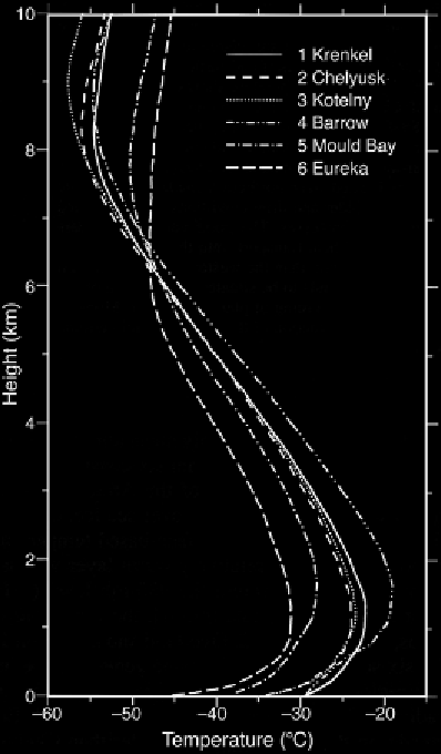
Figure 5.13.
Mean temperature
profiles for February 1987 from six
stations located around the periphery
of the Arctic Ocean: (1) Krenkel
(81°N, 58°E); (2) Chelyuskin (78°N,
104°E); (3) Kotelny (76°N, 138°E);
(4) Barrow (71°N, 86°W); (5) Mould
Bay (76°N, 119°W); and (6) Eureka
(80°N, 86°W) (from Overland et al.,
1997
, by permission of AMS).
typical annual cycle of inversion characteristics based on more than 6,000 raw-
insonde ascents for station Zhigansk in Siberia (68.8°N, 123.4°E) and more than
2,000 ascents over the central Arctic Ocean from the NP program (Serreze et al.,
1992b
). The latter figure shows the predominance of strong surface or near surface
based inversions in winter and the weaker elevated inversions in summer. The shal-
low mixed layer typically present in winter over the Arctic Ocean is masked because
of the limited resolution of the rawinsonde data very near the surface. This mixed
layer is related to the conductive heat flux through the snow and ice. Note that these
are mean conditions - the inversion depth and intensity vary regionally and exhibit
considerable variability on daily to weekly time scales.
The Arctic inversion has a number of important climate effects. An inversion
represents strong vertical stability, limiting the depth of vertical mixing of sensible
heat and moisture. As noted previously, condensate plumes emanating from wide
open water areas, that extend to 4 km in the atmosphere and persist for up to 200 km
downwind, have been identified during winter. The frequency at which such events
can occur is determined in part by the strength of the inversion layer. Elevated con-
centrations of pollution gases and aerosols have been observed to coincide with