Geoscience Reference
In-Depth Information
10
0
−
10
−
20
30
−
−
40
Latitude
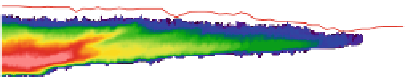
Fig. 3.4
Cross section of CloudSat radar reflectivities (
color shaded
) and CALIPSO retrieved
cloud top height (
red line
). The
vertical dotted line
depicts the location of the single pixel used in
the retrieval analysis (Adapted from
Posselt et al.
(
2008a
), Fig. 1b)
information about the retrieved state (
Rodgers 2000
;
Cooper et al. 2003
,
2007
;
L'Ecuyer et al. 2006
). Though the relationship between satellite measurements and
geophysical quantities may be complex and nonlinear, computational constraints
often restrict retrievals to simplified frameworks. MCMC can be effectively used to
robustly diagnose the uncertainty in a satellite retrieval, to improve the implemen-
tation of more efficient algorithms, and in some cases, to perform the retrieval itself
(
Tamminen and Kyrola 2001
;
Tamminen 2004
).
In this section, we briefly highlight the use of an MCMC algorithm for
diagnosing uncertainties in an ice cloud property retrieval. Vertically integrated
ice mass (ice water path; IWP) and ice particle effective radius are obtained from
relative differences in absorption of infrared radiation by clouds at two channels
in the infrared window (wavelengths between 8 and 14
m,
Inoue 1985
and
Prabhakara et al. 1988
). Split-window retrievals provide global estimates of climate-
relevant characteristics of widespread thin cirrus clouds under both daytime and
nighttime conditions. Retrieved cloud properties from the split-window technique
are known to be sensitive to uncertainties in cloud top height (
Miller et al. 2000
;
Cooper et al. 2003
), cloud geometric thickness (
Hong et al. 2007
), and ice crystal
shape (
Cooper et al. 2003
;
Baum et al. 2005
).
Posselt et al.
(
2008a
) examined these
sources of uncertainty by applying an MCMC algorithm to a cloud scene observed
by the Moderate Resolution Imaging Spectroradiometer (MODIS). A portion of the
results corresponding to analysis of the retrieval solution for a single pixel (Fig.
3.4
),
is presented below. Additional details on the case, as well as results from the entire
scene, can be found in
Posselt et al.
(
2008a
,
b
).
The cloud of interest was associated with the warm frontal portion of an
extratropical cyclone off the United States East Coast at 1730 UTC 22 November
2006 (Fig.
3.4
). In-cloud temperatures were uniformly below 25
ı
C and the cloud
was approximately 4 km thick. Cloud top and base were obtained from CloudSat
and CALIPSO radar and lidar profiles, respectively. The forward radiative transfer
model consisted of a combination of OPTRAN for gaseous transmission (
Kleespies
et al. 2004
), and the Successive Order of Interaction (SOI) model for cloud
particle scattering and absorption (
Heidinger et al. 2006
;
O'Dell et al. 2006
). Cloud
properties were retrieved from MODIS brightness temperatures at 11.0 and 13.3
m
wavelengths.


Search WWH ::

Custom Search