Geoscience Reference
In-Depth Information
NHMFST 2010/07/28 04:00Z FT= 3:00
850
VOR
850
STRM
NHMFST 2010/07/28 04:00Z FT= 3:00
850
VOR
850
STRM
CNTL
VALID= 07/28
15:00HKT
VALID= 07/28
15:00HKT
VOR
STRM
CNT=
(KNOT)
50.00 MAX=
MAX=
2014.61
51.05
MIN=
MIN=
−
1751.53
5.76
VOR
STRM
CNT=
(KNOT)
50.00 MAX=
MAX=
1524.52
50.38
MIN=
MIN=
−
1455.09
3.78
−
750
−
500
−
250
0
250
500
750
−
750
−
500
−
250
0
250
500
750
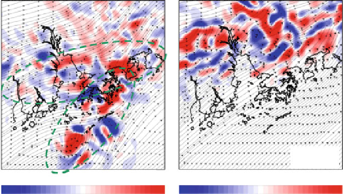
Fig. 22.9
h forecast relative vorticity on 850 hPa level (positive/cyclonic vorticity in
red
and vice versa for
blue
) using radar retrieval winds (
left
) and CNTL from 0300 UTC model run
T
C
3
For wind monitoring and windshear alerting, the LIDAR at HKIA has employed
a special scan strategy, comprising the following scans:
(a) Plan-position Indicator (PPI) scans (or conical scans) to provide the weather
forecasters with an overview of the wind condition in the vicinity of HKIA—
There are three PPI scans, namely, with the elevation angles of
3
ı
and
6
ı
in the current implementation. The former two scans are mainly used for
monitoring the wind along the arrival glide paths (which have smaller elevation
angles, viz.
1:4
ı
,
3
ı
from the ground), and the last one dedicated to the departure
glide paths (which have larger elevation angles, viz.
= 6
ı
from the ground).
The PPI scans are blocked by the Air Traffic Control Tower to the north.
(b) Range-height Indicator (RHI) scans (or vertical-slice scans) to measure the
vertical structure of the windshear features, e.g. interaction between sea breeze
and the background flow, hydraulic jump in cross-mountain airflow, etc.
(c) Glide-path scans to focus on the wind conditions along the glide paths for
operational windshear alerting—The LIDAR measures the headwind profile to
be encountered by the aircraft and significant wind changes in the profile are
detected automatically (
Shun and Chan 2008
).
22.4.2
3DVAR Analysis of LIDAR's Radial Velocity Data
To better visualize the complex airflow around HKIA in the assessment of low-level
windshear, the present seection studies the possibility of retrieving the 2D wind
Search WWH ::

Custom Search