Geoscience Reference
In-Depth Information
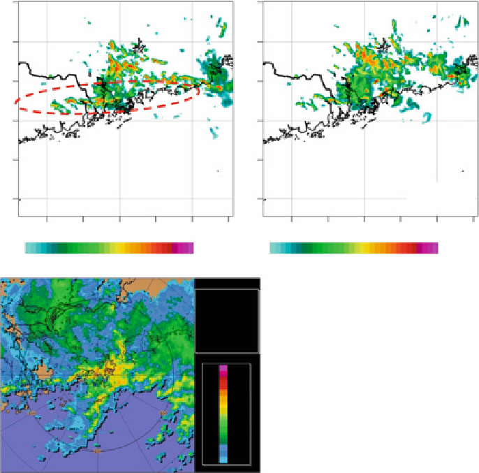
Forecast Equivalent Reflectivity
from RAPIDS-NHM
2010-07-28 03 UTC
T+05 h forecast
Forecast Equivalent Reflectivity
from RAPIDS-NHM
2010-07-28 03 UTC
T+05 h forecast
2010-07-28 16 HKT
2010-07-28 16 HKT
25
°
N
25
°
N
24
°
N
24
°
N
23
°
N
23
°
N
22
°
N
22
°
N
21
°
N
21
°
N
CNTL
20
°
N
20
°
N
112
°
E
113
°
E
114
°
E
115
°
E
116
°
E
117
°
E
112
°
E
113
°
E
114
°
E
115
°
E
116
°
E
117
°
E
dBZ
dBZ
10 15 20 24 28 32 34 38 41 44 47 50 53 56 58 60
10 15 20 24 28 32 34 38 41 44 47 50 53 56 58 60
hk_comp
CAPPI
R_C_030_128
Task: PPIVOL_.
PRF:576/432
Height:3.0 km
Max Range:128 km
15:00:01
28 JUL 2010 HKT
>300
---
200
150
10
7
5
3
15
1
1
300
200
150
10
7
50
3
1
1
1
0.50
0.15
0.50
Fig. 22.8
h forecast of equivalent reflectivity at 0800 UTC using radar retrieval winds and
CNTL. Radar CAPPI reflectivity at 0700 UTC is shown in
lower panel
T
C
5
are operated by the Hong Kong Observatory (HKO) at the Hong Kong International
Airport. Locations of the LIDAR systems are shown in Fig.
22.12
. They are coherent
LIDARs using a 2-
m laser beam with pulse energy of 2 mJ. The measureable range
reaches 10 km and the range resolution is about 100 m.
Since the majority of windshear at HKIA occurs in clear-air weather conditions
such as terrain-disrupted airflow (70 % of pilot reports of windshear encounter)
and sea breeze (20 % of the reports), LIDAR turns out to be well suited for
windshear detection. The remaining windshear events (10 % of the reports) are
mostly associated with convective weather like gust front and microburst. They
are monitored by the Terminal Doppler Weather Radar (TDWR) operated by HKO
(location in Fig.
22.12
). A network of ground-based anemometers and weather
buoys has also been set up inside and around HKIA for windshear detection.
Search WWH ::

Custom Search