Geoscience Reference
In-Depth Information
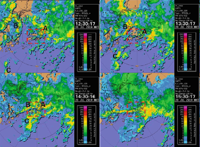
Fig. 22.4
Radar CAPPI reflectivity imagery at 0430, 0530, 0630, 0730 UTC on 28 July 2010
(1230, 1330, 1430 and 1530 HKT respectively). Area of HK is marked in
red dashed box
following hour or so, the former band remained nearly stationary over Hong Kong,
and the latter area moved eastwards gradually. The intersection of the two areas
of thunderstorms resulted and the quasi-stationary nature of the east-oriented rain
band brought about heavy downpour of rain over Hong Kong. Between 09 and 10
UTC, the east-west oriented rainband and the surface convergence line moved south
gradually and rain over the territory weakened gradually.
Frequently occurring short waves could be analyzed in the westerly airflow in the
lower to middle troposphere as shown in the wind fields retrieved from the multiple
radars. The retrieved winds at a height of 2 km above mean sea level could be found
in Fig.
22.5
. Between 07 and 09 UTC (15 and 17 HKT) of 28 July 2010 when the
rain was the heaviest over HKIA, the east-west oriented rain band was found to have
a number of short waves in the westerly at 2 km level. These waves were expected
to trigger and sustain the occurrence of intense convection over Hong Kong. To the
south of the westerly waves, there was active southwesterly flow bringing moisture
from the South China Sea towards the coast of Guangdong.
Similar wavy activity could also be observed from the radar-retrieved winds at a
height of 5 km above mean sea level. Therefore, the westerly waves in the middle
and lower troposphere were conductive to the intense convective developments.
During 09 UTC, the winds over Pearl River Estuary changed from southwesterly
to west-northwesterly. There was a deeper wave passing along the coastal areas of
Search WWH ::

Custom Search