Geoscience Reference
In-Depth Information
17:12 28/07/2010 - 18:00 28/07/2010
16:24 28/07/2010 - 17:12 28/07/2010
15:36 28/07/2010 - 16:24 28/07/2010
14:48 28/07/2010 - 15:36 28/07/2010
14:00 28/07/2010 - 14:48 28/07/2010
mm
0
0.5
2
5
10
20
30
40
50
70
100 150 200 300 400 500 600 > 600
Hong Kong Observatory
~50 km
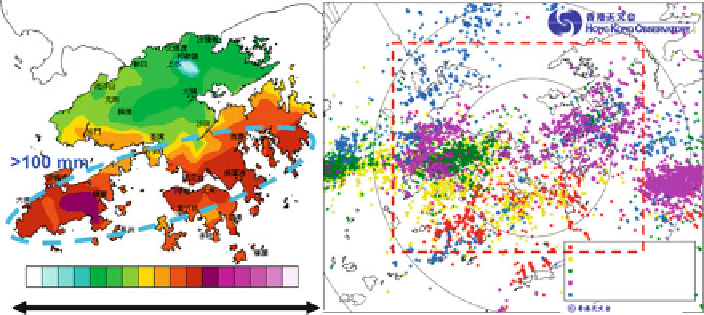
Fig. 22.3
Total accumulated rainfall (color in mm) from 0600 to 1000 UTC on 28 July 2010
(
left
). Distribution of cloud-to-ground lightning strokes during the same period (colored according
to different record time) (
right
)
coast. Further aloft on 200 hPa level, the coast of Guangdong was located between
a deep westerly trough to the north and an east-west oriented ridge axis to the south
where divergence could be analyzed over Hong Kong and adjacent regions. The
supply of moist air at low level, the upward motion in the middle level and the
divergence at the upper level were all favourable to the occurrence of heavy rain
over the coastal regions. Convective unstable environment was also revealed from
radiosonde ascent in Hong Kong at 0000 UTC on 28 July 2010 in which K-index of
40 K and CAPE of around 3,000 J/kg were found together with a saturated condition
between 900 and 500 hPa.
With the aforementioned dynamic and thermodynamic setup, two mesoscale
convective systems (MCS) developed over the east of Pearl River Estuary and
another over western Guangdong (satellite image omitted) during the late morning
on 28 July 2010. Moreover, isolated thunderstorms developed over the seas just
south of Hong Kong. Merging of thunderstorms could be readily observed in the
radar imageries (Fig.
22.4
). At about 05 UTC on 28 July 2010, three areas of
thunderstorms could be analyzed in the vicinity of Hong Kong, namely, an east-west
oriented band to the east of Hong Kong (labelled “A”), a north-south oriented band
to the west of Hong Kong (labelled “B”) and isolated thunderstorms over the seas
to the southwest of Hong Kong (labelled “C”). The band “A” was basically quasi-
stationary, whereas thunderstorms in “B” and “C” were moving towards Hong Kong
in the next couple of hours. The dense network of anemometers on the surface of
Hong Kong shows that there are mesoscale shear lines over the territory in this heavy
rain event. Such shear lines appear to be associated with the convergence between
outflow from the thunderstorms and the background southwesterly winds. Around
0730 UTC, the thunderstorms merged and there was a “X” shape in the areas of
intense convection, namely, the intersection of a basically east-west oriented band
of heavy rain, and another band with north to south-southwest orientation. In the
Search WWH ::

Custom Search