Geoscience Reference
In-Depth Information
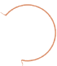
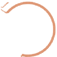
Fig. 13.3
Example of land
distance correlation tensor for
point 4.8 km from coast in
Monterey Bay, California,
USA. Observation point is
given by white X mark.
Horizontal length scales are
assumed homogenous at
30 km. The land distance
tensor spreads the
correlations from the
observation point along the
contours of the Monterey Bay
coastline
Frame
71
Distance
4.8 km
0
.5
1
13.3.2
Vertical Correlations
Vertical correlation length scales vary with location and depth and evolve from one
analysis cycle to the next in the 3DVAR. They are defined on the basis of either:
(1) background density vertical gradients in pressure space, or (2) background
density differences in isopycnal space. In the vertical density gradient option, a
change in density stability criterion is used to define a well-mixed layer. The change
in density criterion is then scaled by the background vertical density gradient at each
grid location and grid level according to,
h
v
D
s
=.@=@
z
/
(13.7)
where h
v
is the vertical correlation length scale,
s
is the change in density criterion
kg m
3
/
(
0:15
z is the vertical density gradient. Surface mixed layer
depths, calculated at each grid point using the same change in density criteria
(
Karra et al. 2000
), are spliced onto the three-dimensional vertical length scale
field computed using (
13.7
). With this modification, surface-only observations
decorrelate at the base of the spatially varying mixed layer. The vertical density
gradient correlations are computed each update cycle from the background den-
sity fields, thereby allowing the vertical scales to evolve with time and capture
changes in mixed layer, thermocline depths, and the formation of mode waters.
Overall, the method produces vertical correlation length scales that vary with depth
and location, and are long when the water column stratification is weak and short
when the water column is strongly stratified.
,and
@¡=@


Search WWH ::

Custom Search