Geoscience Reference
In-Depth Information
the greatest havoc. To understand the altered precipitation patterns fostered by volcanic
weather, we must first grasp the principles of general circulation of the atmosphere. Because
of the tilt of the Earth in relation to the sun and the different heat absorption rates of land and
sea, solar insolation of the planet is irregular. Uneven heating in turn creates an air pressure
gradient across the latitudes of the globe. Wind is the weatherly expression of these temper-
ature and pressure differentials, transporting heat from the tropics to the poles, moderating
temperature extremes, and carrying evaporated water from the oceans over the land to sup-
port plant and animal life. The major meridional circulation patterns, measuring thousands of
kilometers in breadth, transport energy and moisture horizontally across the globe, creating
continental-scale weather patterns. Meanwhile, at smaller scales, the redistribution of heat
and moisture through the vertical column of the atmosphere produces localized “weather”
phenomena, such as thunderstorms.
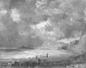
Figure 3.4.
Weymouth Bay
, 1816 (oil on canvas), John Constable (1776-1837). The Victoria & Albert Mu-
seum, London, UK. Courtesy of The Bridgeman Art Library.
In the summer after Tambora's eruption, however, the aerosol loading of the stratosphere
heated the upper layer, which bore down upon the atmosphere. The “tropopause” that marks
the ceiling of the Earth's atmosphere dropped lower, cooling air temperatures and displacing
the jet streams, storm tracks, and meridional circulation patterns from their usual course.
By early 1816, Tambora's chilling envelope had created a radiation deficit across the North
Atlantic, altering the dynamics of the vital Arctic Oscillation. Slower-churning warm waters
north of the Azores pumped overloads of moisture into the atmosphere, saturating the skies
while enhancing the temperature gradient that fuels wind dynamics. Meanwhile, air pressure
at sea level plummeted across the mid-latitudes of the North Atlantic, dragging cyclonic storm
tracks southward. Pioneer British climate historian Hubert Lamb has calculated that the influ-
ential Icelandic low-pressure system shifted several degrees latitude to the south during the
cold summers of the 1810s compared to twentieth-century norms, settling in the unfamiliar
domain of the British Isles, ensuring colder, wetter conditions for all of western Europe.
7
Across Britain, a radical spike in gale-force westerlies saw platoons of rain-bearing clouds
march in from the Atlantic month after month—an airy gray army that brought misery to
farmers across Britain and the western continent. In a Constable painting from October 1816,
Weymouth Bay—a pretty, sheltered cove on England's south coast where the artist was on
honeymoon—sits in fragile sunshine under churning gray-black skies. A couple of optimist-
ic beachgoers—possibly Constable and his new bride—look certain to be drenched. Every-
where, the volcanic winds blew hard. The larger Arctic Oscillation, principal driver of north-
Search WWH ::

Custom Search