Geoscience Reference
In-Depth Information
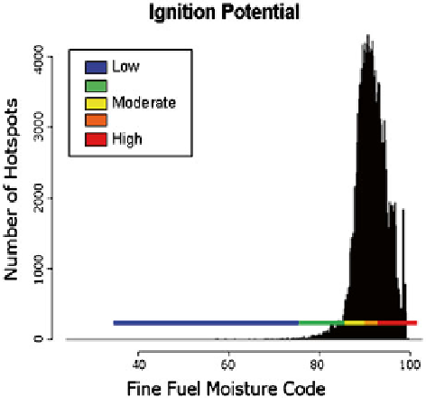
Fig. 7.4
Calibrating the Fine
Fuel Moisture Code (FFMC)
with satellite-detected hot
spots to construct a fi re start
predictor, or “Ignition
Potential” indicator. This
example uses 1 year of
MODIS hot spot data for
sub-Saharan Africa and
corresponding FFMC data for
the hot spot location. Similar
calibrations have been done
for SE Asia and for Central
and South America resulting
in very similar FFMC scale
calibrations
used to represent the moisture content of dead woody debris of different diameter
classes. FFMC fuels are present in virtually all fuel types, and represent the compo-
nent of the fuel complex where fi res start and spread. As such, the FFMC serves as
a universal indicator of potential fi re occurrence, particularly for human-caused
fi res (de Groot et al.
2005
; Wotton
2009
, Fig.
7.4
). The DMC is used as a lightning
fi re predictor in northern forests where lightning ignitions can smolder in the duff
accumulated on the forest fl oor (Wotton
2009
). DC is an indicator of potential for
deep burning fi res and diffi culty of extinguishment. DMC and DC fuels are not
found in the fuel complex of all fuel types, as this depends on vegetation litterfall
and dead organic matter decomposition rates. Therefore, the FFMC has global
application and the DMC and DC are only relevant in fuel types with signifi cant
organic soil development or dead woody debris fuel load. The FWI System also has
three fi re behavior indices, which are general indicators of rate of fi re spread (Initial
Spread Index, ISI), fuel available for combustion within a moving fl ame front
(Buildup Index, BUI), and head fi re intensity (Fire Weather Index, FWI). The FWI
component is also used as a general indicator of fi re danger. The Daily Severity
Rating (DSR) is a power function of the FWI that represents diffi culty of fi re control
(Van Wagner
1970
).
The Global EWS-Fire uses ground-based and remotely sensed data to prepare
early warning products. Fire danger is calculated with Global Forecast System
data from the US National Centers for Environmental Prediction (NCEP).
9
The
Global EWS currently provides 1-7 day forecasted FWI System data that are cali-
brated to commonly used threshold values that identify low to extreme conditions
9
For further information, see Global Forecast System details at
http://www.emc.ncep.noaa.gov
.
Search WWH ::

Custom Search