Geoscience Reference
In-Depth Information
Bodas-Salcedo et al.
2011
) was carried out using four climate models. The study focussed
on a region in the north Pacific, characterised by a rich mixture of different cloud types,
and showed that, while all models capture the basic features of these diagnostics, they also
show a lack of low-level, non-precipitating cloud (cumulus congestus and mixed-phase
layered clouds). In future, this analysis will be extended to other models as part of the
second Cloud Feedback Intercomparison Project (CFMIP-2) which is part of CMIP5 (see
2.3.1.2 Diurnal Cycle of Clouds and Precipitation There is a vast amount of evidence
that shows that the diurnal cycle of precipitation is misrepresented in models (e.g., Dai and
Trenberth
2004
; Bechtold et al.
2004
; Stratton and Stirling
2011
). All show that the peak in
precipitation and outgoing longwave radiation over land occurs several hours too early.
Realistic representation of the diurnal cycle of clouds and precipitation in models is
important because the diurnal cloud-sun correlation rectifies onto the mean radiation
balance, affecting climate simulation and weather prediction (Wang et al.
2007
, and ref-
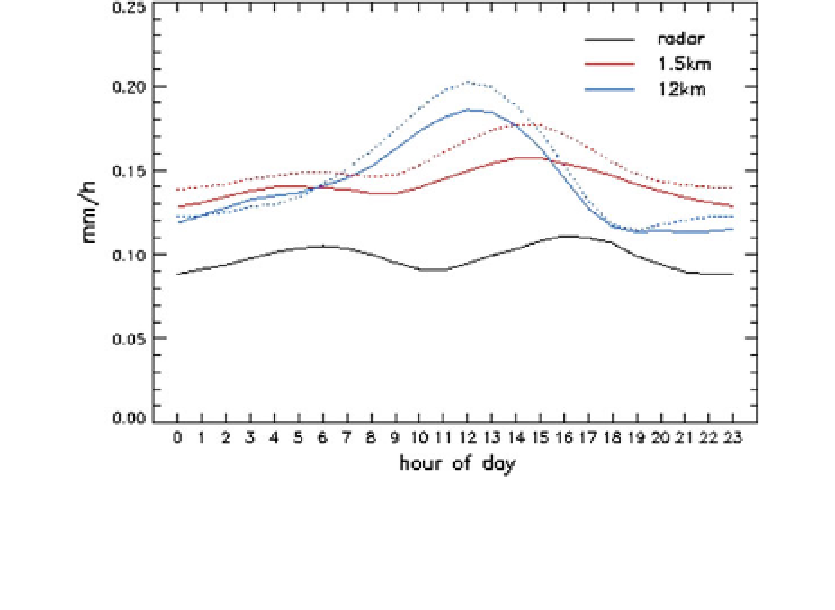
erences therein). Studies with high-resolution models which explicitly represent convec-
tion show improved representation of the diurnal cycle (e.g., Clark et al.
2007
; Hohenegger
et al.
2009
; Love et al.
2011
; Kendon et al.
2012
; and see Fig.
3
), with convection peaking
later in the day. Studies with global climate models which use ''superparametrisation''
techniques (where thousands of embedded cloud-resolving models (CRMs) are used to
handle sub-grid cloud physics instead of parametrisations) show similar improvements in
the diurnal cycle of rainfall over land (e.g., Pritchard
2011
).
Wang et al. (
2007
) attempted to address this shortcoming of convective parametrisa-
tions by changing the entrainment/detrainment rates for deep and shallow convection. They
found that this prolonged the development and reduced the strength of deep convection,
Fig. 3 Diurnal cycle of rainfall (mm/h) in radar and 1.5 and 12 km Regional Climate Models. Results
correspond to years 2003-2010 in the radar, and years 1990-1997 (solid) and 2000-2007 (dotted) in the
models. Plotted is the mean rainfall at each hour of the day, across all southern UK grid boxes and all
8 years
in
the
respective
data
sets.
From
Kendon
et
al.
(
2012
). Copyright
2012
AMS
(
http://