Geoscience Reference
In-Depth Information
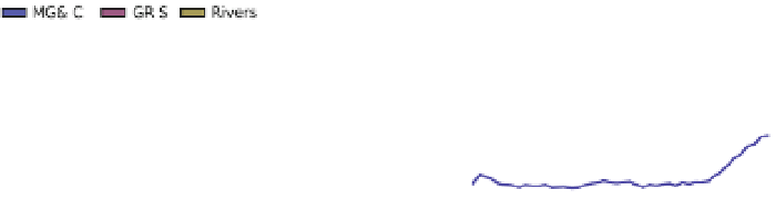
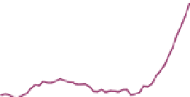
2500
MG&IC
GRIS
Rivers
2000
1500
1000
500
0
500
1960
1970
1980
1990
2000
year
Fig. 6 Left Total meltwater runoff and total river runoff into the Arctic Ocean. Right Cumulative deviations
in annual freshwater flows from mountain glaciers and ice caps (MG&IC), Greenland ice sheet (GRIS), and
rivers relative to average values for 1961-1992
available for a wide range of different hydrological basins, from small catchments of a few
square kilometers in size to the major river basins in the PADB. In contrast, accessible data
from water chemistry monitoring are limited to a much smaller set of stations, which cover
a significantly smaller area and also a much less complete range of basin sizes.
Figure
7
summarizes the accessible length of time series for discharge, and waterborne
sediment and carbon data in hydrologically monitored Arctic areas. The average length of
the time series for the various parameters, and the corresponding share of the PADB that is
monitored, is further summarized in Table
5
.
Results from this analysis further show a marked difference in the characteristics of
monitored and unmonitored areas (Fig.
8
). For example, monitored areas are distinctly
dominated by the taiga eco-region, while unmonitored areas are generally strongly defined
by tundra-type vegetation. This tendency is particularly evident for discharge monitoring in
all regions and for all monitoring parameters in Asia. The most balanced monitoring, in
terms of eco-region proportions, is for carbon monitoring in Europe, while the most
unbalanced monitoring is found in North America and Asia. Such regional monitoring
differences complicate the interpretation of observation data differences between different
parts of the PADB.
6 Discussion
Robust scientific understanding of climate and water systems requires access to relevant
information on changes to flows of water and waterborne constituents. Gaps in under-
standing and unreliability in GCM projections imply, for example, that costly dimen-
sioning decisions for infrastructure and buildings may be more or less risk-prone than
expected from the model results, or that changes in agricultural, and food and water
security conditions are not properly accounted for.
In this paper, we have aimed to contribute to a more complete picture of several of the
central components required for AHC change assessment and adaptation planning at
drainage basin scales. Specifically, we have investigated three overarching topics per-
taining to the relevance of GCM projections for Arctic drainage basins, the understanding
of hydro-climatic change in these basins beyond just precipitation and the spatiotemporal
basin coverage of Arctic hydrological and hydrochemical monitoring systems.