Geoscience Reference
In-Depth Information
Schl
¨
ssel et al.
1997
; Wijesekera et al.
1999
). The downward freshwater flux at the sea
surface establishes a haline diffusive molecular layer (or freshwater skin of the ocean)
(Katsaros and Buettner
1969
) that is characterized by a salinity gradient, with salinity
differences across this freshwater skin sometimes greater than 4 salinity units. The residual
effects of the rain-induced skin layers can even be stronger at the highest rain rates
(Schl ¨ssel et al.
1997
). This freshwater skin stabilizes the near-surface layer (Ostapoff
et al.
1973
) and tends to dampen free convection in the upper oceanic boundary layer.
These conditions motivate the development of autonomous SSS drifters able to monitor
the salinity at less than 50-cm depth. Using such instruments, Reverdin et al. (
2012
)
documented salinity freshening between 15-cm and 50-cm depth in the tropical oceans.
Sudden salinity decreases are often associated with local rainfall and vertical salinity
gradients that last for a few hours, depending, among other factors, on wind speed con-
ditions. The haline molecular diffusion layer that is established in the upper ocean during
rainfall can thus be important for the radiometric observation of the sea surface at low
microwave frequencies. At centimeter wavelengths, the dielectric constant is modified by
the sea surface salinity (e.g., Klein and Swift
1977
; Yueh et al.
2001
) and any change of the
latter might cause interpretation problems when comparing remotely measured surface
salinity at these frequencies to deeper in situ measurements.
Hence, under rainy conditions (or just after a rainfall), the satellite-derived SSS better
characterizes the salinity at the ocean-atmosphere interface rather than the 1-10-m deep
in situ samples. Whether accumulated precipitation can be estimated from changes in
salinity at the ocean surface as observed from space remains, however, an open question, as
assumptions have to be made about the penetration depth of the freshwater. In addition,
assimilation of the new satellite SSS data into ocean circulation models having limited
vertical resolution also challenges our modeling perspectives concerning the dynamics of
the first centimeters to first meter of the ocean surface.
In the following section, we discuss signatures of precipitation detected in the new
SMOS SSS data. First, the strong SSS spatiotemporal variability associated with rain
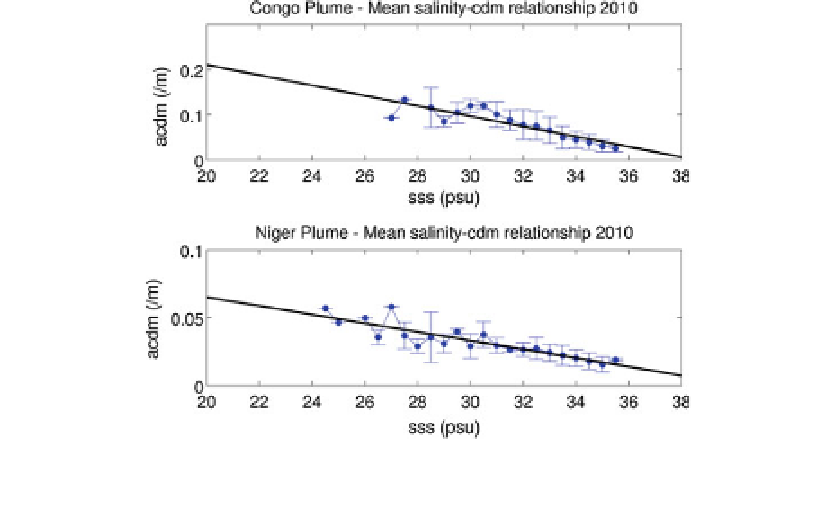
Fig. 12 a
CDOM
(490) to SMOS SSS dependence in the eastern tropical Atlantic averaged over year 2010 for
the Congo(Top) and Niger (Bottom) River Plumes. The mean a
CDOM
(490) per 0.5 bins is shown as a solid
black line ±1 standard deviation (vertical bars)