Geoscience Reference
In-Depth Information
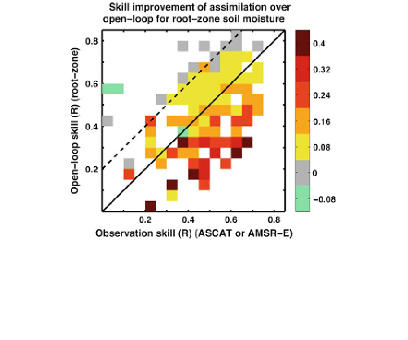
Fig. 13 Root zone soil moisture skill improvement (DR) from assimilating either ASCAT or AMSR-E
surface soil moisture retrievals as a function of (ordinate) the open loop model skill and (abscissa) the
observation skill. Skill improvement (DR) is defined as the skill of the assimilation product minus the open
loop skill, with skill based only on days with data available from both satellites. Skill is assessed versus
in situ measurements from the SCAN and Murrumbidgee networks. Significant improvements are found in
the area below the dashed line where the skill of the retrievals may be lower than that of the open loop by up
to 0.2. Adapted from Draper et al. (
2012
)
open loop (toward the bottom right hand corner). (The results are very similar if the
ordinate measures surface soil moisture skill; not shown). Figure
13
thus provides a
practical demonstration of the minimum skill required for soil moisture observations to be
beneficial in a land data assimilation system and confirms the findings obtained by Reichle
et al. (
2008b
) using synthetically generated observations. In summary, the assimilation of
active or passive microwave data significantly improves the model root zone soil moisture
estimates by a similar amount, even in cases where the assimilated surface soil moisture
retrievals are less skillful than the open loop soil moisture estimates.
3.4.3 Combining Precipitation Observations and Surface Soil Moisture Retrievals
Liu et al. (
2011a
) used both precipitation observations and surface soil moisture retrievals
within the GEOS-5 LDAS and investigated their relative contributions to the skill of root
zone soil moisture estimates. Relative to baseline soil moisture estimates from MERRA,
their study investigates soil moisture skill derived from (1) land model forcing corrections
based on large-scale, gauge-, and satellite-based precipitation observations and (2)
assimilation of surface soil moisture retrievals from AMSR-E. Three precipitation products
were used (separately) to correct the MERRA precipitation toward gauge- and satellite-
based observations: the NOAA Climate Prediction Center Merged Analysis of Precipita-
tion (CMAP) pentad product (''standard'' version), the Global Precipitation Climatology
Project (GPCP) version 2.1 pentad product, and the NOAA Climate Prediction Center
(CPC) daily unified precipitation analysis over the United States.