Geoscience Reference
In-Depth Information
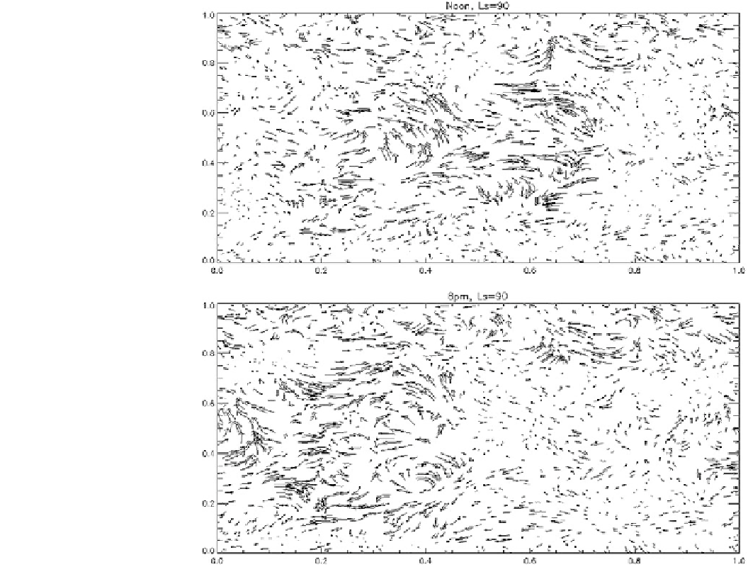
Fig. 19.1
Surface winds on
Mars generated from the LMD/
Oxford Mars Climate Database,
which encapsulates GCM output.
Here, global noon and evening
winds are shown for the northern
spring equinox (Ls = 90). The
arrows indicate wind direction,
the arrow length indicates the
speed. The fastest part of the
wind pattern (corresponding to
local afternoon) moves westward
over the 6 h between these
snapshots. Data courtesy of
Laboratoire de Meteorologie
Dynamique
winds and observed dunes. One global study was by
Blumberg and Greeley (1996) which found (at a 4 9 5
grid
resolution) a generally good agreement, except in the North
American Deserts and the Arabian peninsula. They also
found the GCM predictions were not effective at estimating
the dune type that was formed.
In that context, the challenges encountered by Tokano
(2008) and others in attempting to model the distinct dune
pattern of Titan 9 where far fewer of the surface properties
forcing a GCM are known 9 seem rather forbidding.
Remarkably, some progress may have been made; one
GCM at least appears to be able to explain the observed
dune pattern as largely due to exceptional winds near the
equinoxes, and the dessication of low latitudes (i.e., the
formation of a wide equatorial desert belt) is a result found
in
relatively little progress on Venus GCMs as far as near-
surface conditions are concerned.
One early Martian study was by Lee and Thomas (1995)
who calculated the drift potential and resultant drift
potential of winds generated by a Mars GCM. They noted
that Martian winds provide generally unimodal transport,
and thus barchan and transverse dunes should be most
common (as observed) with very few star or linear dunes
(they did note a couple of regions of linear dunes, in one
instance inferred to be due to the funneling of wind by local
topography).
Naturally, geomorphologists may be interested in wind
patterns at a smaller scale. It is impractical to run a global
model at a scale wherein the environment of individual
dunes (say 1 km) is resolved—the model grid would just be
too large to run. So a high-resolution model covering only a
small part of the planet (a 'mesoscale' model) can be
applied, with its boundary conditions determined by a
GCM. This approach is called 'nesting'. Such models are
able to capture the effects of topography, and so can be used
to estimate sand transport pathways.
several
different
models,
suggesting
it
is
a
general
property of Titan's circumstances.
At Venus, some broad predictions (Saunders et al. 1990)
suggested slope winds would be the dominant factor, and
some large-scale wind patterns were suggested on the basis
of
the
known
topography,
but
so
far
there
has
been
Search WWH ::

Custom Search