Geoscience Reference
In-Depth Information
subtle (e.g., partly vegetated) dunes such as the parabolic
dunes on the Canadian prairies (e.g., Wolfe and Hugenholtz
2009) and on particularly uniform-colored dunes such as
airborne lidar there are shown in Figs.
18.16
and
18.17
.
18.6
Radar Studies of Dunes
RADAR (RAdio Detection And Ranging) has evolved from
its origins as a means of detecting aircraft and ships to a
wide range of sensing techniques, both imaging and noni-
maging. We discuss certain nonimaging techniques (GPR)
later in this section, but of most interest to geomorpholo-
gists is imaging radar, which is in fact our principal source
of knowledge about dunes on Venus and Titan. In part for
this reason, we devote some space in this topic to describing
radar remote sensing.
Most imaging radar uses a technique called Synthetic
Aperture Radar, or SAR. This relies on the radar platform
moving relative to the scene, and the radar echoes are
processed into an image by isolating echoes from different
parts of the scene by their different echo time and different
Doppler shift. This computationally-intensive processing
allows an image with much higher spatial resolution (i.e.,
smaller pixels) to be synthesized than the footprint of the
antenna (which is determined by the wavelength and
the size or 'real aperture'). This magical transformation of
the signal into an image was originally performed with
curved mirrors, but is now rather straightforward to perform
with modern computers. The first civilian SAR imaging of
the Earth was accomplished in 1978 by NASA's Seasat,
which imaged land surfaces as well as the sea (though the
fact that a radar reconnaissance satellite experiment, 'Quill',
was flown some 14 years earlier was only declassified as we
write this in 2012!). An example Seasat image, of the Al-
godones dunes, is shown in Fig.
18.18
.
After Seasat, several brief but productive experiments
were made with the space shuttle (Shuttle Imaging Radar,
SIR-A in 1982; SIR-B in 1984; and SIR-C, augmented with
a German X-band radar X-SAR, flew twice in 1994). In the
meantime, after a number of false starts, Venus mapping
radars were developed in the 1980s, with the Soviet Venera-
15 and -16 flying in 1983, and NASA's Magellan in 1989,
and several other countries developed Earth-observing radar
satellites. These include the European Space Agency ESA's
ERS-1 (European Remote Sensing Satellite) in 1991, ERS-2
in 1995 and Envisat in 2002; the Japanese JERS-1 in 1992,
and Canada's Radarsat-1 and -2 (1995 and 2002); several
countries since have launched radar imaging satellites, lar-
gely for military purposes. Since SIR-C, the only imaging
radar NASA has flown has been Cassini (in 1997). Many of
the satellites mentioned above also conduct nonimaging
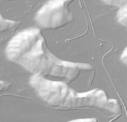
Fig. 18.17
Shaded relief LiDAR map of White Sands: Zoom into an
area just *200 m across showing the shape of individual dunes, which
are up to about 7 m high. The looping lines a berm about 0.5 m high,
bulldozed to maintain clear parking areas and roads; the small
rectangular features are cars and visitor facilities. Compare with kite
presumably correspond to the destabilization wavelength (see
Chap. 5
).
Data acquired in January 2009 by the National Center for Airborne
Laser Mapping (NCALM) through Seed Grant program to Ryan C.
Ewing. Image courtesy Ryan Ewing
from the ICESAT laser altimeter have been used to study
Antarctic megadunes of snow (on both Earth and Mars,
these altimeters are on satellites in near-polar orbits, so the
density of measurement points is maximized where the
groundtracks converge at high latitude) as well as to doc-
ument dune advance in the Arabian Peninsula (of 6 and
25 m over a 6-month timeframe, Dhabboor 2008).
In recent years, computational tools to perform topo-
graphic modeling from 'random' images (as opposed to the
well-posed pairs in the satellite systems above) have
become widely available, and it seems that taking a series of
images with a simple digital camera may be the preferred
way of measuring topography in the field at scales smaller
than the orbital datasets. One caution should be noted:
stereo matching relies on finding tiepoints in the images so
in a surface covered with a material that is uniform in
brightness and color, such methods may fail. This may
cause problems for studies of some dunes with very uniform
sand properties, especially on overcast days where the
lighting is isotropic. Thus laser ranging does have appli-
cation at smaller scales, e.g., from aircraft and at ground
level (the latter was discussed in
Chap. 16
).
Airborne laser scanning does an excellent job of
obtaining precision topography over areas up to several
kilometers across. Such topography is good for defining

Search WWH ::

Custom Search