Geoscience Reference
In-Depth Information
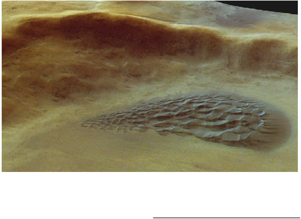
Fig. 18.15
A view generated by draping color nadir imaging from
the Mars Express HRSC over a DEM generated from stereo images
acquired on May 27, 2004, and shows the crater with a dune field
located in the north-western part of the Argyre Planitia crater basin.
The image is centred at Mars longitude 303E and latitude 43S. The
image resolution is approximately 16.2 m/pixel. Credit ESA/DLR/FU
Berlin (G. Neukum)
aligned orthogonal to the orbital motion of the spacecraft,
then a long noodle of ground, hundreds of pixels wide, is
covered, with a spectrum for each pixel.
Data of this type are acquired by several instruments
flying today at dune worlds. Cassini has a Visual and
Infrared Mapping Spectrometer (VIMS) which has provided
information on the composition and geometry of Titan's
dunes. At Mars, prominent instruments have been CRISM
(Compact Reconnaissance Imaging Spectrometer for Mars,
built at the first author's present institution) and OMEGA
(Observatoire pour la Minéralogie, l'Eau, les Glaces et
l'Activité). CRISM (Fig.
18.12
) obtains spectral images
over a *10 km-wide swath with a spatial resolution
of *40 m, analyzing light from 0.36 to 3.92 lm with a
spectral resolution of 6.5 nm; OMEGA's performance is
spectrally similar but with spatial resolution of
only *300 m (CRISM is a much more modern design,
reaching Mars on the Mars Reconnaissance Orbiter in 2006,
OMEGA originally being developed for the Russian Mars-
96 mission in the mid-1990s, being reflown on Mars
Express in 2003). Data from these instruments suggest that
gypsum (e.g., Horgan et al. 2009).
18.5
Topography From Imaging
We are evolved to instantly derive the shape of things by
reconciling the slightly different views from our two sepa-
rated eyes: stereoscopic vision. The same geometric oper-
ation can also be performed with image pairs or sets taken
from orbit, and is now done rather systematically on both
Earth and Mars.
A near-global topography dataset for Earth, spanning
83N-83S, has been generated using stereo-pair images by
the ASTER (Advanced Spaceborne Thermal Emission and
Reflection Radiometer) instrument onboard the Terra
satellite, as a result of a joint effort between NASA and the
Japanese Ministry of Economy, Trade, and Industry
(METI). The instrument has shortwave- and thermal-infra-
red cameras, as well as a 15 m-resolution visible and near-
IR camera which features a nadir-looking and a canted
backward-looking imager. The nadir and canted images
form a stereo pair from which a 60 km 9 60 km digital
elevation model (DEM) can be extracted (Figs.
18.13
,
18.14
). Hundreds of thousands of these local DEMs have
been assembled into a global product covering 99 % of the
Earth's landmass with 30 m postings. This product is a
Search WWH ::

Custom Search