Geoscience Reference
In-Depth Information
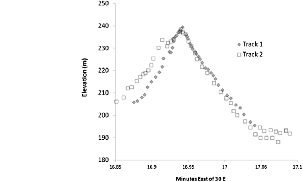
Fig. 16.2
Two adjacent GPS
traverses across a linear dune in
Quattaniya, Egypt (see also
a simple handheld GPS receiver.
The traverse is about 300 m long;
the dune grades into a wide
shallow plinth, not shown here, to
the west (left) and is about 50 m
high
user depends on the distance between the receiver and each
satellite, so each time measurement defines a spherical shell
in space where the receiver must lie. Having fixes from
several satellites defines several shells, and the intersection
of these shells defines a small volume (usually only a few
meters across) in which the receiver must lie. All this
elaborate calculation was performed by computer in back-
pack-sized units in the 1980s, which progressively shrank
(more or less in parallel with the comparable technology in
mobile telephones) to handheld units in the 1990 and 2000,
and
migration, it is generally the case that the relative positions
of the slipface, crest, etc. are more important than the
absolute position in some reference frame). Convenient
tools now exist (notably Google Earth) to overlay GPS
tracks on satellite imaging (see Fig.
9.5
).
For higher precision (centimeters) a technique called
differential GPS must still be used (it had already become
popular to circumvent the limitations of the SA policy),
wherein a fixed base station and a mobile survey unit
simultaneously record fixes. Since many of the errors (such
as those induced by the propagation of the signal through
the ionosphere) are common to both receivers, they cancel
out when the position of the survey unit relative to the base
station is calculated. Because the accuracy is so high, the
antenna of the survey unit is often mounted on a staff so that
its distance from the ground can be precisely controlled as
the surveyor walks around; a backpack (Fig.
16.3
) is a more
convenient and often adequately accurate solution.
then
mere
thumbnail-sized
devices
incorporated
in
phones and other appliances in the 2010s.
In the 1990 and 2000s, when GPS units became available
and affordable for scientific use, the out-of-the-box accu-
racy was often poorer than some tens of meters, since the
'native' precision of the signals was restricted to US mili-
tary users, a policy termed 'Selective Availability'. How-
ever, in 2000, the SA policy was revoked, allowing
accuracies of a few meters to be obtained with only a single
handheld receiver. This has made mapping the boundaries
of geological features like dunes, or measuring their profiles
by marching or driving across them, almost trivial.
Rather effective shape models of dunes even only a few
meters high can now be constructed with simple handheld
GPS units (which can be set to record coordinates at short
intervals, and can then be downloaded to a computer— e.g.,
Fig.
16.2
.). The accuracy of these may vary, but can be just
a few meters (and except for the measurement of dune
16.2.2
Imaging
Dunes are naturally photogenic targets. G.K. Gilbert's
photographs from the 1890s (a number of which appear in
this topic) are striking were largely enabled by the inno-
vation of photographic film, which let the geologist take his
own pictures (rather than needing a dedicated photographer
along, as had been the case only a decade or two before
Search WWH ::

Custom Search