Geoscience Reference
In-Depth Information
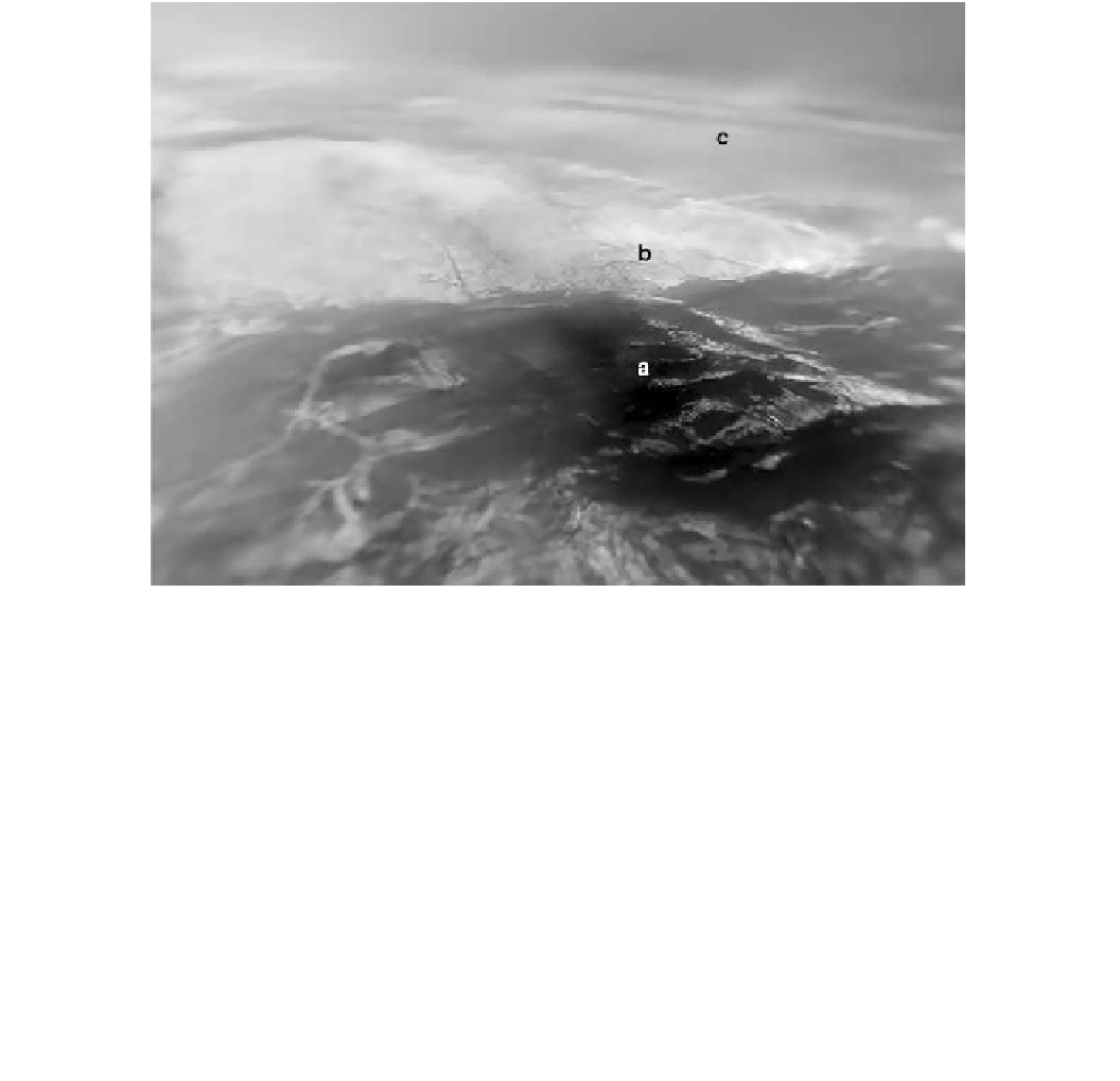
Fig. 13.7
The closest thing we have to an aerial photo on Titan: a
mosaic of images (assembled by Erich Karkoschka of the University of
Arizona) taken during the parachute descent of the Huygens probe.
This scene looks north-west from a simulated altitude of about 25 km.
The probe landed in the dark foreground (a), revealing a riverbed
scene with rounded cobbles on a damp sandy substrate. The most
dramatic pictures were of a network of small rivervalleys in a bright
highland (b)—the distance a-b is about 7 km. Not noticed at the time,
but instrumental in locating the landing site in radar image data, were
two dark streaks—dunes—at (c), about 30 km north of the landing
site. Image credit NASA/ESA/U.Arizona
Mars, the hemispheric arrangement would be reversed only
about 30000 years ago—perhaps during our last ice age,
there were more seas in Titan's south than in the north.
Although the dunes appear almost invariably to be linear
(longitudinal), there have been a handful of counterexamples
identified, albeit at the threshold of the radar resolution.
Lorenz et al. (2006) noticed a 'lattice' pattern where linear
dunes south of a bright topographic obstacle appeared to
blend in with some superposed orthogonal (i.e., transverse)
forms. It was suggested that perhaps the obstacle 'straight-
ened' the fluctuating flow that is associated with the linear
form. Hayes et al. (2012) have examined sharpened radar
images of dunes and found some evidence of barchan forms,
possibly undergoing a transition in orientation. The possi-
bility that such dramatic rearrangements of the climate
system may occur on such short periods raises the question
of whether the aeolian geomorphology can respond fast
enough—the dune pattern observed may represent the result
of winds over tens of thousands of years, and thus perhaps
not only the currently (poorly) observed climate.
An additional class of feature (Fig.
13.13
), that may be
dunes, are what appear to be ridges that Radebaugh et al. has
found in a number of mid-latitude locations. These are
notable in that they resemble the dunes in their size and shape,
but apparently have a different composition or surface texture
Fig. 13.8
Titan's dunes (and sand-free interdunes) at about 13 N,
56 W seen at 2 microns wavelength by the Cassini Visual and Infrared
Mapping Spectrometer (VIMS). The sand is dark at this wavelength
and at optical wavelengths and in radar, providing an important
compositional constraint. Image courtesy of J. Barnes
this different forcing to have important consequences,
notably favoring a transport of moisture to the northern
hemisphere. This appears to be a compelling explanation
(Aharonson et al. 2009) for the fact that the vast majority of
Titan's hydrocarbon lakes are found around the north pole.
Recent work suggests that the net interhemispheric transport
of moisture is manifested as a longer rainy season (summer)
in the North (Schneider et al. 2012). Clearly, moisture
availability can affect sand transport, and thus an effect of
the asymmetric seasons on the dunefields is not surprising.
An interesting side-note to this astronomical climate forcing
is that, much like the Croll-Milankovich cycles that pace the
Earth's ice ages and influence the polar layered terrain on

Search WWH ::

Custom Search